You are here: Home > Network List > XL12 - Hangay Dome, Mongolia Stations List
> Station HV27 HV27 > Earthquake Result Viewer
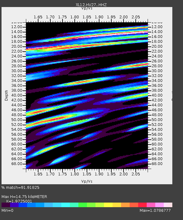
HV27 HV27 - Earthquake Result Viewer
| Earthquake location: |
Southern Sumatra, Indonesia |
| Earthquake latitude/longitude: |
-0.8/98.7 |
| Earthquake time(UTC): |
2015/03/03 (062) 10:37:31 GMT |
| Earthquake Depth: |
38 km |
| Earthquake Magnitude: |
6.4 MWP, 6.4 MO |
| Earthquake Catalog/Contributor: |
NEIC PDE/NEIC ALERT |
|
| Network: |
XL Hangay Dome, Mongolia |
| Station: |
HV27 HV27 |
| Lat/Lon: |
50.54 N/101.51 E |
| Elevation: |
1140 m |
|
| Distance: |
51.2 deg |
| Az: |
2.295 deg |
| Baz: |
183.598 deg |
| Ray Param: |
0.06750991 |
| Estimated Moho Depth: |
14.75 km |
| Estimated Crust Vp/Vs: |
1.97 |
| Assumed Crust Vp: |
6.419 km/s |
| Estimated Crust Vs: |
3.254 km/s |
| Estimated Crust Poisson's Ratio: |
0.33 |
|
| Radial Match: |
91.91825 % |
| Radial Bump: |
400 |
| Transverse Match: |
73.24848 % |
| Transverse Bump: |
400 |
| SOD ConfigId: |
7019011 |
| Insert Time: |
2019-04-17 04:44:21.444 +0000 |
| GWidth: |
2.5 |
| Max Bumps: |
400 |
| Tol: |
0.001 |
|

Signal To Noise
| Channel | StoN | STA | LTA |
| XL:HV27: :HHZ:20150303T10:46:00.219989Z | 24.962898 | 1.4289922E-6 | 5.7244645E-8 |
| XL:HV27: :HHN:20150303T10:46:00.219989Z | 9.492572 | 8.7674584E-7 | 9.2361255E-8 |
| XL:HV27: :HHE:20150303T10:46:00.219989Z | 1.9220407 | 4.3205992E-7 | 2.247923E-7 |
| Arrivals |
| Ps | 2.4 SECOND |
| PpPs | 6.5 SECOND |
| PsPs/PpSs | 8.8 SECOND |


