You are here: Home > Network List > TA - USArray Transportable Network (new EarthScope stations) Stations List
> Station G59A Clarenceville, QC, USA > Earthquake Result Viewer
G59A Clarenceville, QC, USA - Earthquake Result Viewer
| Earthquake location: |
Northern Chile |
| Earthquake latitude/longitude: |
-20.4/-69.2 |
| Earthquake time(UTC): |
2015/03/03 (062) 12:45:18 GMT |
| Earthquake Depth: |
105 km |
| Earthquake Magnitude: |
5.2 MW |
| Earthquake Catalog/Contributor: |
ISC/ISC |
|
| Network: |
TA USArray Transportable Network (new EarthScope stations) |
| Station: |
G59A Clarenceville, QC, USA |
| Lat/Lon: |
45.08 N/73.18 W |
| Elevation: |
36 m |
|
| Distance: |
65.2 deg |
| Az: |
356.869 deg |
| Baz: |
175.852 deg |
| Ray Param: |
0.058131114 |
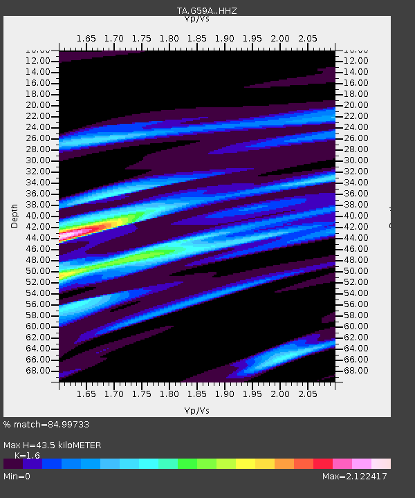
| Estimated Moho Depth: |
43.5 km |
| Estimated Crust Vp/Vs: |
1.60 |
| Assumed Crust Vp: |
6.419 km/s |
| Estimated Crust Vs: |
4.012 km/s |
| Estimated Crust Poisson's Ratio: |
0.18 |
|
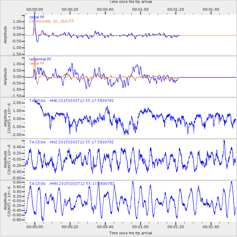
| Radial Match: |
84.99733 % |
| Radial Bump: |
292 |
| Transverse Match: |
44.900303 % |
| Transverse Bump: |
388 |
| SOD ConfigId: |
7019011 |
| Insert Time: |
2019-04-17 04:51:34.442 +0000 |
| GWidth: |
2.5 |
| Max Bumps: |
400 |
| Tol: |
0.001 |
|
Signal To Noise
| Channel | StoN | STA | LTA |
| TA:G59A: :HHZ:20150303T12:55:17.589978Z | 1.1098877 | 2.4244684E-7 | 2.1844266E-7 |
| TA:G59A: :HHN:20150303T12:55:17.589978Z | 1.3017452 | 5.120213E-7 | 3.9333452E-7 |
| TA:G59A: :HHE:20150303T12:55:17.589978Z | 0.76647806 | 6.8576077E-7 | 8.946907E-7 |
| Arrivals |
| Ps | 4.3 SECOND |
| PpPs | 17 SECOND |
| PsPs/PpSs | 21 SECOND |


