You are here: Home > Network List > TA - USArray Transportable Network (new EarthScope stations) Stations List
> Station E47A Iron Bridge, ON, CAN > Earthquake Result Viewer
E47A Iron Bridge, ON, CAN - Earthquake Result Viewer
| Earthquake location: |
Mona Passage |
| Earthquake latitude/longitude: |
18.1/-68.4 |
| Earthquake time(UTC): |
2014/05/28 (148) 21:15:04 GMT |
| Earthquake Depth: |
91 km |
| Earthquake Magnitude: |
5.8 MWW, 5.3 MI, 5.9 MWR |
| Earthquake Catalog/Contributor: |
NEIC PDE/NEIC COMCAT |
|
| Network: |
TA USArray Transportable Network (new EarthScope stations) |
| Station: |
E47A Iron Bridge, ON, CAN |
| Lat/Lon: |
46.45 N/83.28 W |
| Elevation: |
246 m |
|
| Distance: |
30.8 deg |
| Az: |
339.661 deg |
| Baz: |
151.44 deg |
| Ray Param: |
0.079085484 |
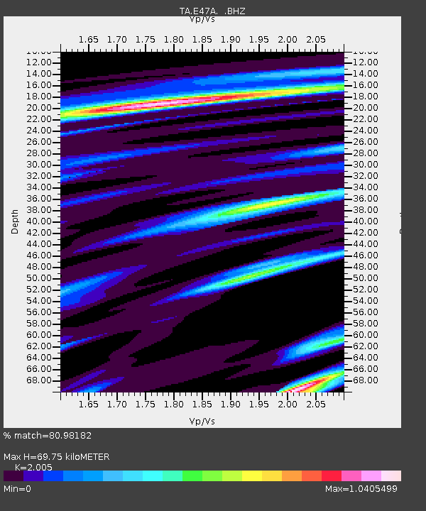
| Estimated Moho Depth: |
69.75 km |
| Estimated Crust Vp/Vs: |
2.01 |
| Assumed Crust Vp: |
6.467 km/s |
| Estimated Crust Vs: |
3.225 km/s |
| Estimated Crust Poisson's Ratio: |
0.33 |
|
| Radial Match: |
80.98182 % |
| Radial Bump: |
385 |
| Transverse Match: |
66.899635 % |
| Transverse Bump: |
400 |
| SOD ConfigId: |
626651 |
| Insert Time: |
2014-06-11 21:44:51.866 +0000 |
| GWidth: |
2.5 |
| Max Bumps: |
400 |
| Tol: |
0.001 |
|

Signal To Noise
| Channel | StoN | STA | LTA |
| TA:E47A: :BHZ:20140528T21:20:41.999987Z | 3.5854309 | 8.7241233E-7 | 2.4332147E-7 |
| TA:E47A: :BHN:20140528T21:20:41.999987Z | 5.6783185 | 5.523363E-7 | 9.7271105E-8 |
| TA:E47A: :BHE:20140528T21:20:41.999987Z | 2.7005558 | 4.999376E-7 | 1.8512397E-7 |
| Arrivals |
| Ps | 12 SECOND |
| PpPs | 30 SECOND |
| PsPs/PpSs | 42 SECOND |


