You are here: Home > Network List > TA - USArray Transportable Network (new EarthScope stations) Stations List
> Station TUL1 Leonard, OK, USA > Earthquake Result Viewer
TUL1 Leonard, OK, USA - Earthquake Result Viewer
| Earthquake location: |
Mona Passage |
| Earthquake latitude/longitude: |
18.1/-68.4 |
| Earthquake time(UTC): |
2014/05/28 (148) 21:15:04 GMT |
| Earthquake Depth: |
91 km |
| Earthquake Magnitude: |
5.8 MWW, 5.3 MI, 5.9 MWR |
| Earthquake Catalog/Contributor: |
NEIC PDE/NEIC COMCAT |
|
| Network: |
TA USArray Transportable Network (new EarthScope stations) |
| Station: |
TUL1 Leonard, OK, USA |
| Lat/Lon: |
35.91 N/95.79 W |
| Elevation: |
256 m |
|
| Distance: |
30.0 deg |
| Az: |
311.624 deg |
| Baz: |
118.877 deg |
| Ray Param: |
0.07929276 |
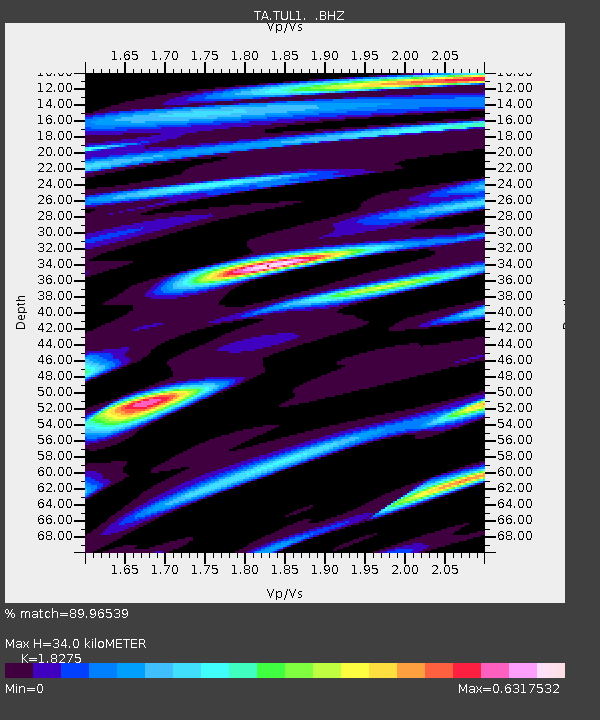
| Estimated Moho Depth: |
34.0 km |
| Estimated Crust Vp/Vs: |
1.83 |
| Assumed Crust Vp: |
6.498 km/s |
| Estimated Crust Vs: |
3.555 km/s |
| Estimated Crust Poisson's Ratio: |
0.29 |
|
| Radial Match: |
89.96539 % |
| Radial Bump: |
323 |
| Transverse Match: |
63.16841 % |
| Transverse Bump: |
400 |
| SOD ConfigId: |
626651 |
| Insert Time: |
2014-06-11 21:47:03.252 +0000 |
| GWidth: |
2.5 |
| Max Bumps: |
400 |
| Tol: |
0.001 |
|
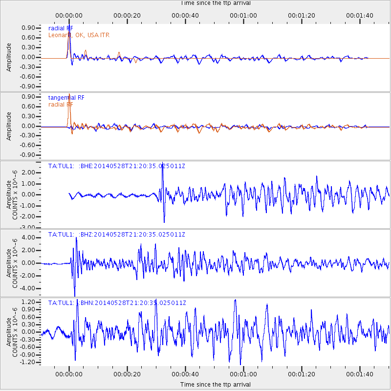
Signal To Noise
| Channel | StoN | STA | LTA |
| TA:TUL1: :BHZ:20140528T21:20:35.025011Z | 25.171297 | 1.8779789E-6 | 7.460795E-8 |
| TA:TUL1: :BHN:20140528T21:20:35.025011Z | 4.861579 | 4.92725E-7 | 1.01350814E-7 |
| TA:TUL1: :BHE:20140528T21:20:35.025011Z | 8.092063 | 9.570657E-7 | 1.1827216E-7 |
| Arrivals |
| Ps | 4.7 SECOND |
| PpPs | 14 SECOND |
| PsPs/PpSs | 18 SECOND |


