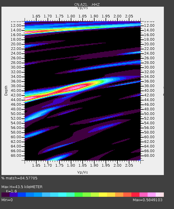
A21 ST-ANDRE, QC - Earthquake Result Viewer

Earthquake location: Near Coast Of Guerrero, Mexico
Earthquake latitude/longitude: 16.5/-98.1
Earthquake time(UTC): 2014/05/24 (144) 08:24:47 GMT
Earthquake Depth: 17 km
Earthquake Magnitude: 5.7 MWW, 5.6 MWB, 5.7 MWC
Earthquake Catalog/Contributor: NEIC PDE/NEIC COMCAT
Network: CN Canadian National Seismograph Network
Station: A21 ST-ANDRE, QC
Lat/Lon: 47.70 N/69.69 W
Elevation: 46 m
Distance: 38.9 deg
Az: 30.816 deg
Baz: 226.678 deg
Ray Param: 0.075269826
Estimated Moho Depth: 43.5 km
Estimated Crust Vp/Vs: 1.60
Assumed Crust Vp: 6.419 km/s
Estimated Crust Vs: 4.012 km/s
Estimated Crust Poisson's Ratio: 0.18
Radial Match: 84.57785 %
Radial Bump: 400
Transverse Match: 63.19222 %
Transverse Bump: 400
SOD ConfigId: 626651
Insert Time: 2014-06-12 09:43:38.821 +0000
GWidth: 2.5
Max Bumps: 400
Tol: 0.001

Signal To Noise

ChannelStoNSTALTA
CN:A21: :HHZ:20140524T08:31:41.870005Z5.59757955.877883E-71.0500759E-7
CN:A21: :HHN:20140524T08:31:41.870005Z1.57396631.9247561E-71.22287E-7
CN:A21: :HHE:20140524T08:31:41.870005Z2.26783043.1523774E-71.390041E-7
Arrivals
Ps4.4 SECOND
PpPs16 SECOND
PsPs/PpSs21 SECOND