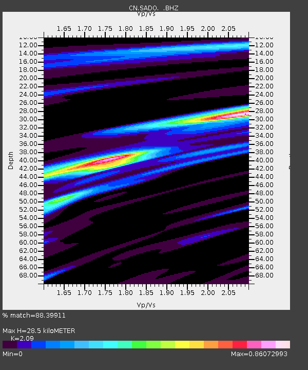
SADO SADOWA, ON - Earthquake Result Viewer

Earthquake location: Near Coast Of Guerrero, Mexico
Earthquake latitude/longitude: 16.5/-98.1
Earthquake time(UTC): 2014/05/24 (144) 08:24:47 GMT
Earthquake Depth: 17 km
Earthquake Magnitude: 5.7 MWW, 5.6 MWB, 5.7 MWC
Earthquake Catalog/Contributor: NEIC PDE/NEIC COMCAT
Network: CN Canadian National Seismograph Network
Station: SADO SADOWA, ON
Lat/Lon: 44.77 N/79.14 W
Elevation: 243 m
Distance: 32.4 deg
Az: 25.654 deg
Baz: 215.662 deg
Ray Param: 0.07865953
Estimated Moho Depth: 28.5 km
Estimated Crust Vp/Vs: 2.09
Assumed Crust Vp: 6.577 km/s
Estimated Crust Vs: 3.147 km/s
Estimated Crust Poisson's Ratio: 0.35
Radial Match: 88.39911 %
Radial Bump: 400
Transverse Match: 74.78401 %
Transverse Bump: 400
SOD ConfigId: 626651
Insert Time: 2014-06-12 09:45:22.260 +0000
GWidth: 2.5
Max Bumps: 400
Tol: 0.001

Signal To Noise

ChannelStoNSTALTA
CN:SADO: :BHZ:20140524T08:30:46.00001Z3.666145.386143E-71.4691591E-7
CN:SADO: :BHN:20140524T08:30:46.00001Z3.29460841.6869694E-75.1203944E-8
CN:SADO: :BHE:20140524T08:30:46.00001Z3.92623833.509274E-78.938006E-8
Arrivals
Ps5.1 SECOND
PpPs12 SECOND
PsPs/PpSs18 SECOND