You are here: Home > Network List > CI - Caltech Regional Seismic Network Stations List
> Station VCS Vincent Substation, Palmdale, CA, USA > Earthquake Result Viewer
VCS Vincent Substation, Palmdale, CA, USA - Earthquake Result Viewer
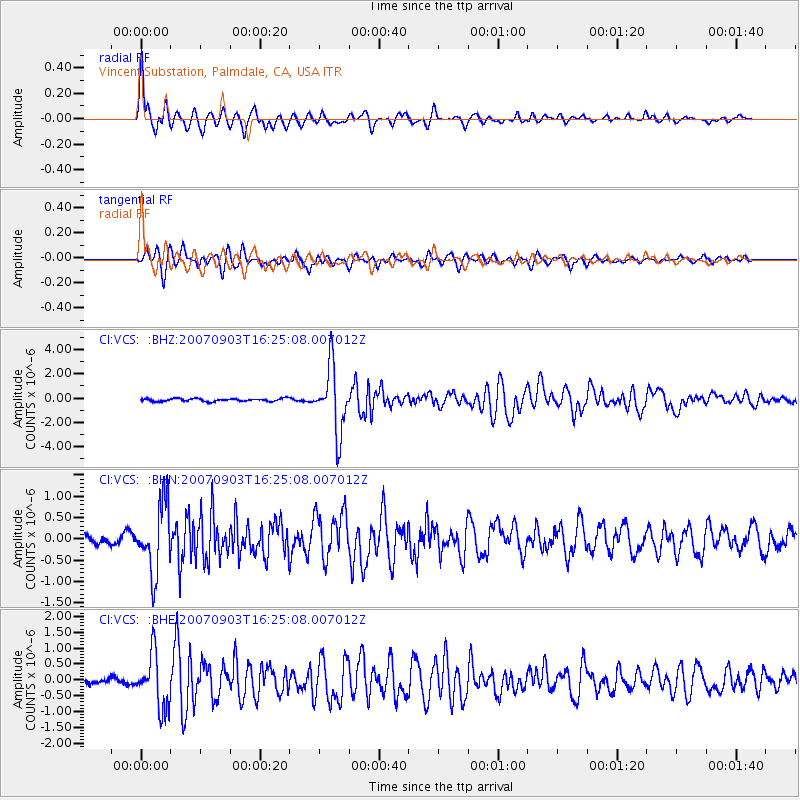
| Earthquake location: |
Kuril Islands |
| Earthquake latitude/longitude: |
45.8/150.1 |
| Earthquake time(UTC): |
2007/09/03 (246) 16:14:53 GMT |
| Earthquake Depth: |
94 km |
| Earthquake Magnitude: |
6.3 MB, 6.2 MW, 6.2 ME |
| Earthquake Catalog/Contributor: |
WHDF/NEIC |
|
| Network: |
CI Caltech Regional Seismic Network |
| Station: |
VCS Vincent Substation, Palmdale, CA, USA |
| Lat/Lon: |
34.48 N/118.12 W |
| Elevation: |
991 m |
|
| Distance: |
67.4 deg |
| Az: |
63.436 deg |
| Baz: |
310.8 deg |
| Ray Param: |
0.056756325 |
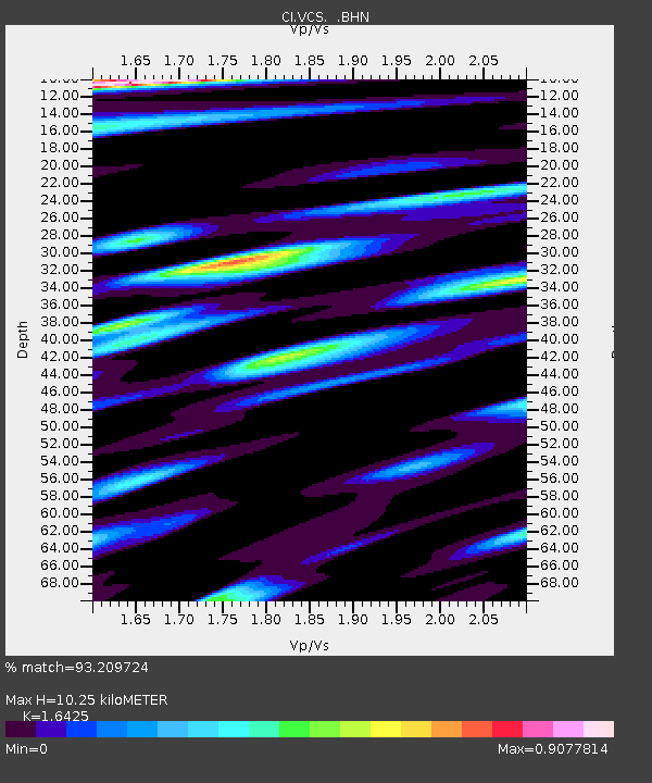
| Estimated Moho Depth: |
10.25 km |
| Estimated Crust Vp/Vs: |
1.64 |
| Assumed Crust Vp: |
6.1 km/s |
| Estimated Crust Vs: |
3.714 km/s |
| Estimated Crust Poisson's Ratio: |
0.21 |
|
| Radial Match: |
93.209724 % |
| Radial Bump: |
393 |
| Transverse Match: |
87.683586 % |
| Transverse Bump: |
400 |
| SOD ConfigId: |
2564 |
| Insert Time: |
2010-02-25 21:06:25.764 +0000 |
| GWidth: |
2.5 |
| Max Bumps: |
400 |
| Tol: |
0.001 |
|
Signal To Noise
| Channel | StoN | STA | LTA |
| CI:VCS: :BHN:20070903T16:25:08.007012Z | 5.238522 | 7.9955714E-7 | 1.5263028E-7 |
| CI:VCS: :BHE:20070903T16:25:08.007012Z | 8.740302 | 8.482201E-7 | 9.7047E-8 |
| CI:VCS: :BHZ:20070903T16:25:08.007012Z | 23.683035 | 2.6861233E-6 | 1.1341973E-7 |
| Arrivals |
| Ps | 1.1 SECOND |
| PpPs | 4.3 SECOND |
| PsPs/PpSs | 5.4 SECOND |


