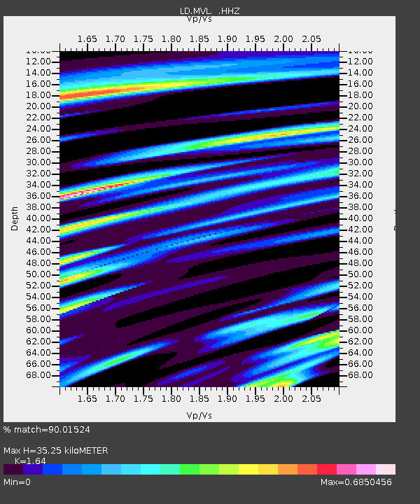
MVL Millersville University, PA - Earthquake Result Viewer

Earthquake location: Near Coast Of Guerrero, Mexico
Earthquake latitude/longitude: 16.5/-98.1
Earthquake time(UTC): 2014/05/24 (144) 08:24:47 GMT
Earthquake Depth: 17 km
Earthquake Magnitude: 5.7 MWW, 5.6 MWB, 5.7 MWC
Earthquake Catalog/Contributor: NEIC PDE/NEIC COMCAT
Network: LD Lamont-Doherty Cooperative Seismographic Network
Station: MVL Millersville University, PA
Lat/Lon: 40.00 N/76.35 W
Elevation: 91 m
Distance: 30.1 deg
Az: 34.657 deg
Baz: 225.241 deg
Ray Param: 0.07941328
Estimated Moho Depth: 35.25 km
Estimated Crust Vp/Vs: 1.64
Assumed Crust Vp: 6.419 km/s
Estimated Crust Vs: 3.914 km/s
Estimated Crust Poisson's Ratio: 0.20
Radial Match: 90.01524 %
Radial Bump: 400
Transverse Match: 66.99095 %
Transverse Bump: 400
SOD ConfigId: 626651
Insert Time: 2014-06-12 09:51:16.783 +0000
GWidth: 2.5
Max Bumps: 400
Tol: 0.001

Signal To Noise

ChannelStoNSTALTA
LD:MVL: :HHZ:20140524T08:30:25.859995Z7.12036755.6988983E-78.003658E-8
LD:MVL: :HHN:20140524T08:30:25.859995Z3.69238733.4981383E-79.473921E-8
LD:MVL: :HHE:20140524T08:30:25.859995Z6.3118143.694859E-75.853878E-8
Arrivals
Ps3.8 SECOND
PpPs13 SECOND
PsPs/PpSs17 SECOND