You are here: Home > Network List > TA - USArray Transportable Network (new EarthScope stations) Stations List
> Station G59A Clarenceville, QC, USA > Earthquake Result Viewer
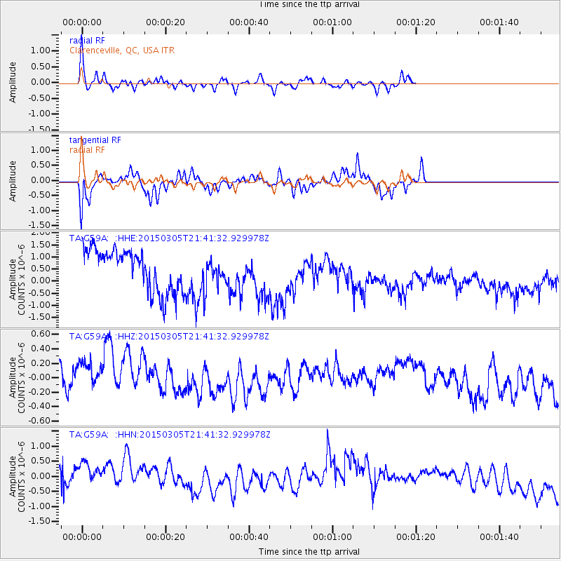
G59A Clarenceville, QC, USA - Earthquake Result Viewer
*The percent match for this event was below the threshold and hence no stack was calculated.
| Earthquake location: |
Near Coast Of Central Chile |
| Earthquake latitude/longitude: |
-29.2/-71.4 |
| Earthquake time(UTC): |
2015/03/05 (064) 21:30:32 GMT |
| Earthquake Depth: |
41 km |
| Earthquake Magnitude: |
5.2 MW |
| Earthquake Catalog/Contributor: |
ISC/ISC |
|
| Network: |
TA USArray Transportable Network (new EarthScope stations) |
| Station: |
G59A Clarenceville, QC, USA |
| Lat/Lon: |
45.08 N/73.18 W |
| Elevation: |
36 m |
|
| Distance: |
74.0 deg |
| Az: |
358.705 deg |
| Baz: |
178.403 deg |
| Ray Param: |
$rayparam |
*The percent match for this event was below the threshold and hence was not used in the summary stack. |
|
| Radial Match: |
69.57297 % |
| Radial Bump: |
285 |
| Transverse Match: |
49.87423 % |
| Transverse Bump: |
359 |
| SOD ConfigId: |
7019011 |
| Insert Time: |
2019-04-17 05:05:26.542 +0000 |
| GWidth: |
2.5 |
| Max Bumps: |
400 |
| Tol: |
0.001 |
|
Signal To Noise
| Channel | StoN | STA | LTA |
| TA:G59A: :HHZ:20150305T21:41:32.929978Z | 1.4940511 | 3.2543417E-7 | 2.1781996E-7 |
| TA:G59A: :HHN:20150305T21:41:32.929978Z | 1.6362721 | 5.916772E-7 | 3.616007E-7 |
| TA:G59A: :HHE:20150305T21:41:32.929978Z | 0.6943207 | 5.9352107E-7 | 8.548227E-7 |
| Arrivals |
| Ps | |
| PpPs | |
| PsPs/PpSs | |


