You are here: Home > Network List > TA - USArray Transportable Network (new EarthScope stations) Stations List
> Station R11A Troy Canyon, Currant, NV, USA > Earthquake Result Viewer
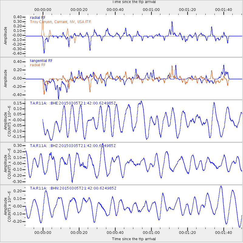
R11A Troy Canyon, Currant, NV, USA - Earthquake Result Viewer
*The percent match for this event was below the threshold and hence no stack was calculated.
| Earthquake location: |
Near Coast Of Central Chile |
| Earthquake latitude/longitude: |
-29.2/-71.4 |
| Earthquake time(UTC): |
2015/03/05 (064) 21:30:32 GMT |
| Earthquake Depth: |
41 km |
| Earthquake Magnitude: |
5.2 MW |
| Earthquake Catalog/Contributor: |
ISC/ISC |
|
| Network: |
TA USArray Transportable Network (new EarthScope stations) |
| Station: |
R11A Troy Canyon, Currant, NV, USA |
| Lat/Lon: |
38.35 N/115.59 W |
| Elevation: |
1756 m |
|
| Distance: |
78.9 deg |
| Az: |
326.067 deg |
| Baz: |
141.65 deg |
| Ray Param: |
$rayparam |
*The percent match for this event was below the threshold and hence was not used in the summary stack. |
|
| Radial Match: |
65.74473 % |
| Radial Bump: |
400 |
| Transverse Match: |
42.97341 % |
| Transverse Bump: |
400 |
| SOD ConfigId: |
7019011 |
| Insert Time: |
2019-04-17 05:06:24.147 +0000 |
| GWidth: |
2.5 |
| Max Bumps: |
400 |
| Tol: |
0.001 |
|
Signal To Noise
| Channel | StoN | STA | LTA |
| TA:R11A: :BHZ:20150305T21:42:00.624985Z | 1.2584496 | 1.2942472E-7 | 1.0284458E-7 |
| TA:R11A: :BHN:20150305T21:42:00.624985Z | 1.9085938 | 1.5033191E-7 | 7.87658E-8 |
| TA:R11A: :BHE:20150305T21:42:00.624985Z | 0.9135058 | 8.434646E-8 | 9.2332705E-8 |
| Arrivals |
| Ps | |
| PpPs | |
| PsPs/PpSs | |


