You are here: Home > Network List > PO - Portable Observatories for Lithospheric Analysis and Research Investigating Seis Stations List
> Station LATQ La Tuque, Quebec, QC > Earthquake Result Viewer
LATQ La Tuque, Quebec, QC - Earthquake Result Viewer
| Earthquake location: |
Near Coast Of Guerrero, Mexico |
| Earthquake latitude/longitude: |
16.5/-98.1 |
| Earthquake time(UTC): |
2014/05/24 (144) 08:24:47 GMT |
| Earthquake Depth: |
17 km |
| Earthquake Magnitude: |
5.7 MWW, 5.6 MWB, 5.7 MWC |
| Earthquake Catalog/Contributor: |
NEIC PDE/NEIC COMCAT |
|
| Network: |
PO Portable Observatories for Lithospheric Analysis and Research Investigating Seis |
| Station: |
LATQ La Tuque, Quebec, QC |
| Lat/Lon: |
47.38 N/72.78 W |
| Elevation: |
163 m |
|
| Distance: |
37.2 deg |
| Az: |
28.768 deg |
| Baz: |
222.791 deg |
| Ray Param: |
0.07624263 |
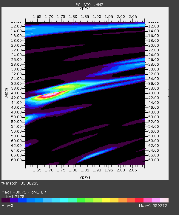
| Estimated Moho Depth: |
39.75 km |
| Estimated Crust Vp/Vs: |
1.72 |
| Assumed Crust Vp: |
6.61 km/s |
| Estimated Crust Vs: |
3.849 km/s |
| Estimated Crust Poisson's Ratio: |
0.24 |
|
| Radial Match: |
83.86263 % |
| Radial Bump: |
400 |
| Transverse Match: |
60.181526 % |
| Transverse Bump: |
400 |
| SOD ConfigId: |
626651 |
| Insert Time: |
2014-06-12 09:55:18.765 +0000 |
| GWidth: |
2.5 |
| Max Bumps: |
400 |
| Tol: |
0.001 |
|

Signal To Noise
| Channel | StoN | STA | LTA |
| PO:LATQ: :HHZ:20140524T08:31:27.539988Z | 5.175333 | 2.8191045E-7 | 5.4471943E-8 |
| PO:LATQ: :HHN:20140524T08:31:27.539988Z | 2.99959 | 1.3389567E-7 | 4.463799E-8 |
| PO:LATQ: :HHE:20140524T08:31:27.539988Z | 2.9985573 | 1.5136939E-7 | 5.048074E-8 |
| Arrivals |
| Ps | 4.7 SECOND |
| PpPs | 15 SECOND |
| PsPs/PpSs | 20 SECOND |


