You are here: Home > Network List > WY - Yellowstone Wyoming Seismic Network Stations List
> Station YUF Upper Falls, WY, USA > Earthquake Result Viewer
YUF Upper Falls, WY, USA - Earthquake Result Viewer
| Earthquake location: |
Near Coast Of Central Chile |
| Earthquake latitude/longitude: |
-29.2/-71.4 |
| Earthquake time(UTC): |
2015/03/05 (064) 21:30:32 GMT |
| Earthquake Depth: |
41 km |
| Earthquake Magnitude: |
5.2 MW |
| Earthquake Catalog/Contributor: |
ISC/ISC |
|
| Network: |
WY Yellowstone Wyoming Seismic Network |
| Station: |
YUF Upper Falls, WY, USA |
| Lat/Lon: |
44.71 N/110.51 W |
| Elevation: |
2394 m |
|
| Distance: |
81.8 deg |
| Az: |
332.986 deg |
| Baz: |
146.17 deg |
| Ray Param: |
0.047276035 |
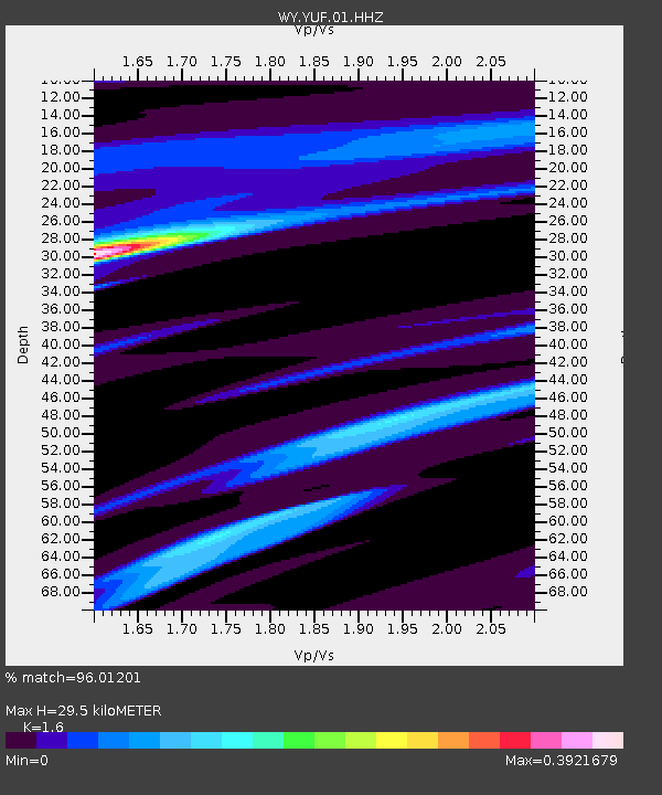
| Estimated Moho Depth: |
29.5 km |
| Estimated Crust Vp/Vs: |
1.60 |
| Assumed Crust Vp: |
6.35 km/s |
| Estimated Crust Vs: |
3.969 km/s |
| Estimated Crust Poisson's Ratio: |
0.18 |
|
| Radial Match: |
96.01201 % |
| Radial Bump: |
151 |
| Transverse Match: |
60.75051 % |
| Transverse Bump: |
400 |
| SOD ConfigId: |
7019011 |
| Insert Time: |
2019-04-17 05:07:40.229 +0000 |
| GWidth: |
2.5 |
| Max Bumps: |
400 |
| Tol: |
0.001 |
|

Signal To Noise
| Channel | StoN | STA | LTA |
| WY:YUF:01:HHZ:20150305T21:42:16.113022Z | 0.34198573 | 9.613849E-9 | 2.8111844E-8 |
| WY:YUF:01:HHN:20150305T21:42:16.113022Z | 0.29182154 | 1.0133521E-8 | 3.472506E-8 |
| WY:YUF:01:HHE:20150305T21:42:16.113022Z | 2.2774086 | 3.2773105E-8 | 1.4390526E-8 |
| Arrivals |
| Ps | 2.9 SECOND |
| PpPs | 12 SECOND |
| PsPs/PpSs | 15 SECOND |


