You are here: Home > Network List > TA - USArray Transportable Network (new EarthScope stations) Stations List
> Station D49A Beulah Township, ON, CAN > Earthquake Result Viewer
D49A Beulah Township, ON, CAN - Earthquake Result Viewer

| Earthquake location: |
Near Coast Of Guerrero, Mexico |
| Earthquake latitude/longitude: |
16.5/-98.1 |
| Earthquake time(UTC): |
2014/05/24 (144) 08:24:47 GMT |
| Earthquake Depth: |
17 km |
| Earthquake Magnitude: |
5.7 MWW, 5.6 MWB, 5.7 MWC |
| Earthquake Catalog/Contributor: |
NEIC PDE/NEIC COMCAT |
|
| Network: |
TA USArray Transportable Network (new EarthScope stations) |
| Station: |
D49A Beulah Township, ON, CAN |
| Lat/Lon: |
47.27 N/81.36 W |
| Elevation: |
416 m |
|
| Distance: |
33.7 deg |
| Az: |
20.783 deg |
| Baz: |
209.988 deg |
| Ray Param: |
0.07809264 |
| Estimated Moho Depth: |
42.5 km |
| Estimated Crust Vp/Vs: |
1.62 |
| Assumed Crust Vp: |
6.467 km/s |
| Estimated Crust Vs: |
3.992 km/s |
| Estimated Crust Poisson's Ratio: |
0.19 |
|
| Radial Match: |
92.04366 % |
| Radial Bump: |
283 |
| Transverse Match: |
74.89535 % |
| Transverse Bump: |
400 |
| SOD ConfigId: |
626651 |
| Insert Time: |
2014-06-12 09:57:07.443 +0000 |
| GWidth: |
2.5 |
| Max Bumps: |
400 |
| Tol: |
0.001 |
|
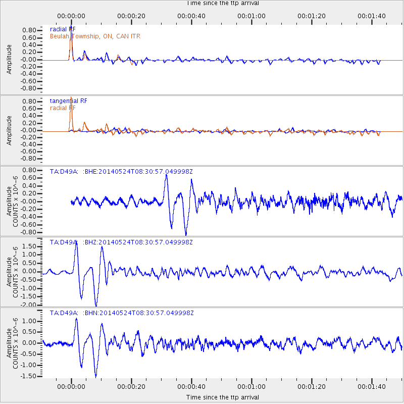
Signal To Noise
| Channel | StoN | STA | LTA |
| TA:D49A: :BHZ:20140524T08:30:57.049998Z | 10.502559 | 9.075913E-7 | 8.6416215E-8 |
| TA:D49A: :BHN:20140524T08:30:57.049998Z | 7.5259953 | 5.7930606E-7 | 7.697401E-8 |
| TA:D49A: :BHE:20140524T08:30:57.049998Z | 5.3847814 | 3.6501925E-7 | 6.77872E-8 |
| Arrivals |
| Ps | 4.4 SECOND |
| PpPs | 16 SECOND |
| PsPs/PpSs | 20 SECOND |


