You are here: Home > Network List > TA - USArray Transportable Network (new EarthScope stations) Stations List
> Station D50A G1974 Best Township, ON, CAN > Earthquake Result Viewer
D50A G1974 Best Township, ON, CAN - Earthquake Result Viewer
| Earthquake location: |
Near Coast Of Guerrero, Mexico |
| Earthquake latitude/longitude: |
16.5/-98.1 |
| Earthquake time(UTC): |
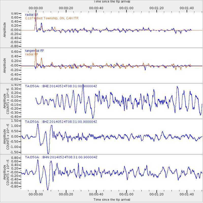
2014/05/24 (144) 08:24:47 GMT |
| Earthquake Depth: |
17 km |
| Earthquake Magnitude: |
5.7 MWW, 5.6 MWB, 5.7 MWC |
| Earthquake Catalog/Contributor: |
NEIC PDE/NEIC COMCAT |
|
| Network: |
TA USArray Transportable Network (new EarthScope stations) |
| Station: |
D50A G1974 Best Township, ON, CAN |
| Lat/Lon: |
47.17 N/79.84 W |
| Elevation: |
331 m |
|
| Distance: |
34.1 deg |
| Az: |
22.466 deg |
| Baz: |
212.493 deg |
| Ray Param: |
0.07788773 |
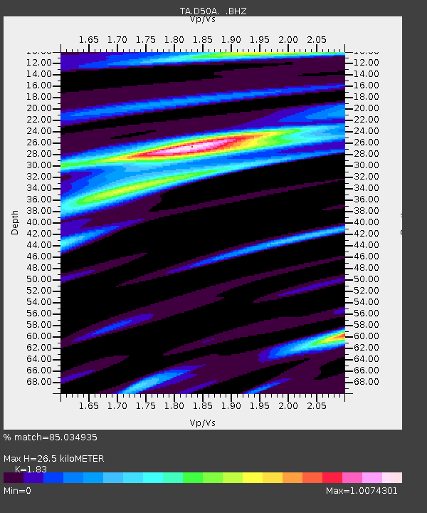
| Estimated Moho Depth: |
26.5 km |
| Estimated Crust Vp/Vs: |
1.83 |
| Assumed Crust Vp: |
6.622 km/s |
| Estimated Crust Vs: |
3.619 km/s |
| Estimated Crust Poisson's Ratio: |
0.29 |
|
| Radial Match: |
85.034935 % |
| Radial Bump: |
400 |
| Transverse Match: |
66.74769 % |
| Transverse Bump: |
400 |
| SOD ConfigId: |
626651 |
| Insert Time: |
2014-06-12 09:57:10.247 +0000 |
| GWidth: |
2.5 |
| Max Bumps: |
400 |
| Tol: |
0.001 |
|
Signal To Noise
| Channel | StoN | STA | LTA |
| TA:D50A: :BHZ:20140524T08:31:00.900004Z | 6.927246 | 6.3796045E-7 | 9.209438E-8 |
| TA:D50A: :BHN:20140524T08:31:00.900004Z | 4.187149 | 3.6855235E-7 | 8.801988E-8 |
| TA:D50A: :BHE:20140524T08:31:00.900004Z | 2.030481 | 1.9778511E-7 | 9.7408005E-8 |
| Arrivals |
| Ps | 3.6 SECOND |
| PpPs | 10 SECOND |
| PsPs/PpSs | 14 SECOND |


