You are here: Home > Network List > TA - USArray Transportable Network (new EarthScope stations) Stations List
> Station D56A ZEC Mazanza, Mont-Saint-Michel, QC, CAN > Earthquake Result Viewer
D56A ZEC Mazanza, Mont-Saint-Michel, QC, CAN - Earthquake Result Viewer
| Earthquake location: |
Near Coast Of Guerrero, Mexico |
| Earthquake latitude/longitude: |
16.5/-98.1 |
| Earthquake time(UTC): |
2014/05/24 (144) 08:24:47 GMT |
| Earthquake Depth: |
17 km |
| Earthquake Magnitude: |
5.7 MWW, 5.6 MWB, 5.7 MWC |
| Earthquake Catalog/Contributor: |
NEIC PDE/NEIC COMCAT |
|
| Network: |
TA USArray Transportable Network (new EarthScope stations) |
| Station: |
D56A ZEC Mazanza, Mont-Saint-Michel, QC, CAN |
| Lat/Lon: |
47.05 N/74.76 W |
| Elevation: |
421 m |
|
| Distance: |
36.1 deg |
| Az: |
27.452 deg |
| Baz: |
220.29 deg |
| Ray Param: |
0.07686547 |
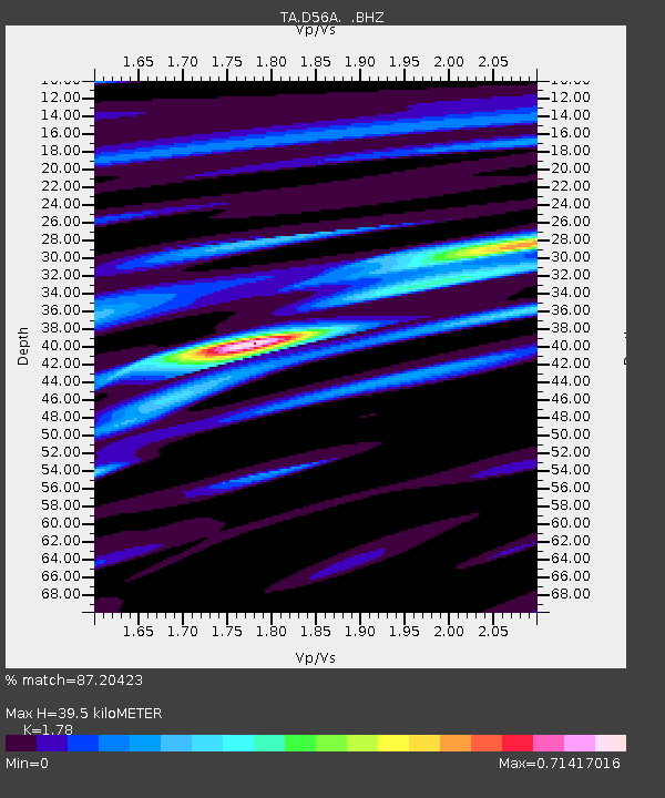
| Estimated Moho Depth: |
39.5 km |
| Estimated Crust Vp/Vs: |
1.78 |
| Assumed Crust Vp: |
6.61 km/s |
| Estimated Crust Vs: |
3.713 km/s |
| Estimated Crust Poisson's Ratio: |
0.27 |
|
| Radial Match: |
87.20423 % |
| Radial Bump: |
400 |
| Transverse Match: |
64.346214 % |
| Transverse Bump: |
400 |
| SOD ConfigId: |
626651 |
| Insert Time: |
2014-06-12 09:57:31.408 +0000 |
| GWidth: |
2.5 |
| Max Bumps: |
400 |
| Tol: |
0.001 |
|
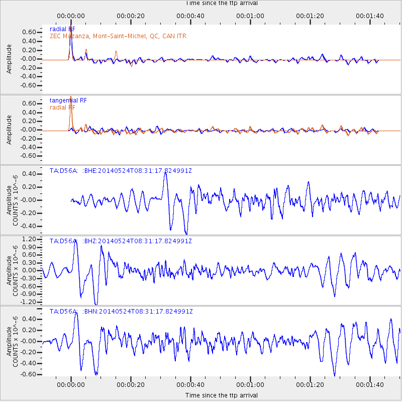
Signal To Noise
| Channel | StoN | STA | LTA |
| TA:D56A: :BHZ:20140524T08:31:17.824991Z | 5.2372737 | 6.620019E-7 | 1.2640201E-7 |
| TA:D56A: :BHN:20140524T08:31:17.824991Z | 5.026869 | 3.0686584E-7 | 6.104513E-8 |
| TA:D56A: :BHE:20140524T08:31:17.824991Z | 3.4319339 | 2.5688018E-7 | 7.484998E-8 |
| Arrivals |
| Ps | 5.0 SECOND |
| PpPs | 15 SECOND |
| PsPs/PpSs | 20 SECOND |


