You are here: Home > Network List > TA - USArray Transportable Network (new EarthScope stations) Stations List
> Station D62A Allapoint, Allagash, ME, USA > Earthquake Result Viewer
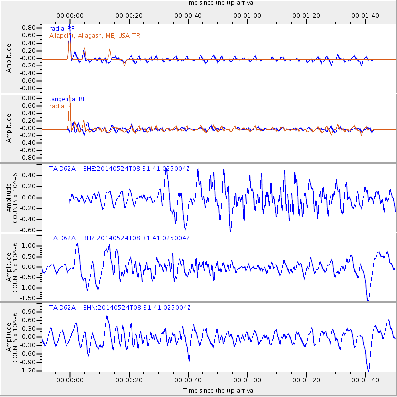
D62A Allapoint, Allagash, ME, USA - Earthquake Result Viewer
| Earthquake location: |
Near Coast Of Guerrero, Mexico |
| Earthquake latitude/longitude: |
16.5/-98.1 |
| Earthquake time(UTC): |
2014/05/24 (144) 08:24:47 GMT |
| Earthquake Depth: |
17 km |
| Earthquake Magnitude: |
5.7 MWW, 5.6 MWB, 5.7 MWC |
| Earthquake Catalog/Contributor: |
NEIC PDE/NEIC COMCAT |
|
| Network: |
TA USArray Transportable Network (new EarthScope stations) |
| Station: |
D62A Allapoint, Allagash, ME, USA |
| Lat/Lon: |
47.08 N/69.05 W |
| Elevation: |
189 m |
|
| Distance: |
38.8 deg |
| Az: |
32.015 deg |
| Baz: |
228.081 deg |
| Ray Param: |
0.075328395 |
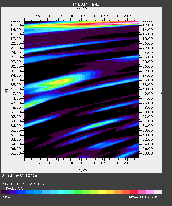
| Estimated Moho Depth: |
10.75 km |
| Estimated Crust Vp/Vs: |
2.08 |
| Assumed Crust Vp: |
6.419 km/s |
| Estimated Crust Vs: |
3.09 km/s |
| Estimated Crust Poisson's Ratio: |
0.35 |
|
| Radial Match: |
81.10276 % |
| Radial Bump: |
353 |
| Transverse Match: |
49.263866 % |
| Transverse Bump: |
400 |
| SOD ConfigId: |
626651 |
| Insert Time: |
2014-06-12 09:57:54.545 +0000 |
| GWidth: |
2.5 |
| Max Bumps: |
400 |
| Tol: |
0.001 |
|
Signal To Noise
| Channel | StoN | STA | LTA |
| TA:D62A: :BHZ:20140524T08:31:41.025004Z | 3.9371476 | 5.4502453E-7 | 1.3843132E-7 |
| TA:D62A: :BHN:20140524T08:31:41.025004Z | 2.0073128 | 2.779178E-7 | 1.3845266E-7 |
| TA:D62A: :BHE:20140524T08:31:41.025004Z | 2.9466841 | 2.485807E-7 | 8.435947E-8 |
| Arrivals |
| Ps | 1.9 SECOND |
| PpPs | 4.8 SECOND |
| PsPs/PpSs | 6.8 SECOND |


