You are here: Home > Network List > TA - USArray Transportable Network (new EarthScope stations) Stations List
> Station E56A St. Veronique, QC, CAN > Earthquake Result Viewer
E56A St. Veronique, QC, CAN - Earthquake Result Viewer
| Earthquake location: |
Near Coast Of Guerrero, Mexico |
| Earthquake latitude/longitude: |
16.5/-98.1 |
| Earthquake time(UTC): |
2014/05/24 (144) 08:24:47 GMT |
| Earthquake Depth: |
17 km |
| Earthquake Magnitude: |
5.7 MWW, 5.6 MWB, 5.7 MWC |
| Earthquake Catalog/Contributor: |
NEIC PDE/NEIC COMCAT |
|
| Network: |
TA USArray Transportable Network (new EarthScope stations) |
| Station: |
E56A St. Veronique, QC, CAN |
| Lat/Lon: |
46.54 N/75.03 W |
| Elevation: |
320 m |
|
| Distance: |
35.6 deg |
| Az: |
27.762 deg |
| Baz: |
220.34 deg |
| Ray Param: |
0.07714135 |
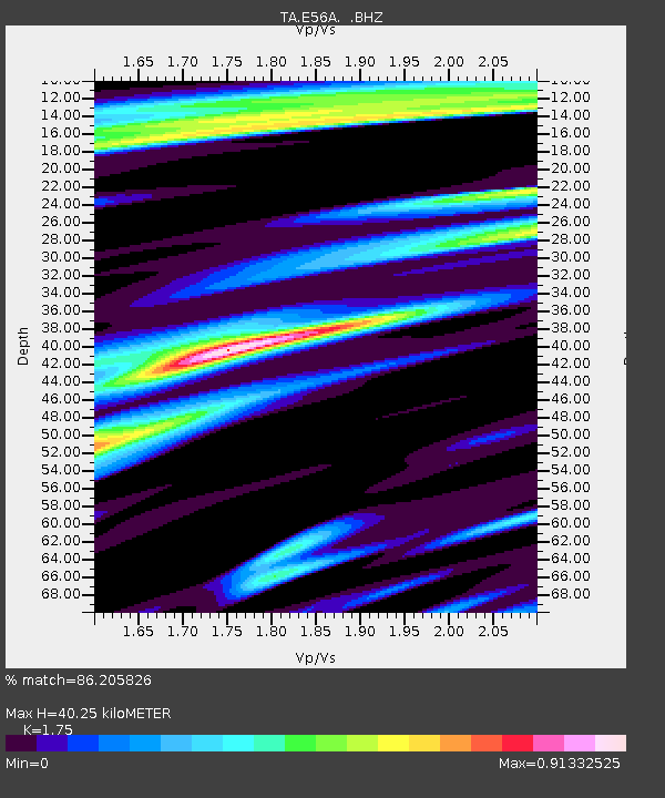
| Estimated Moho Depth: |
40.25 km |
| Estimated Crust Vp/Vs: |
1.75 |
| Assumed Crust Vp: |
6.61 km/s |
| Estimated Crust Vs: |
3.777 km/s |
| Estimated Crust Poisson's Ratio: |
0.26 |
|
| Radial Match: |
86.205826 % |
| Radial Bump: |
400 |
| Transverse Match: |
64.86929 % |
| Transverse Bump: |
400 |
| SOD ConfigId: |
626651 |
| Insert Time: |
2014-06-12 09:58:35.006 +0000 |
| GWidth: |
2.5 |
| Max Bumps: |
400 |
| Tol: |
0.001 |
|
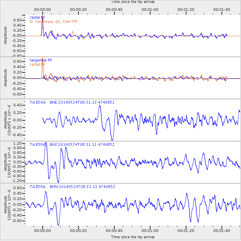
Signal To Noise
| Channel | StoN | STA | LTA |
| TA:E56A: :BHZ:20140524T08:31:13.474985Z | 8.276628 | 6.9842343E-7 | 8.438503E-8 |
| TA:E56A: :BHN:20140524T08:31:13.474985Z | 3.6276224 | 2.428008E-7 | 6.6931115E-8 |
| TA:E56A: :BHE:20140524T08:31:13.474985Z | 2.7216964 | 2.1691791E-7 | 7.9699525E-8 |
| Arrivals |
| Ps | 5.0 SECOND |
| PpPs | 15 SECOND |
| PsPs/PpSs | 20 SECOND |


