You are here: Home > Network List > TA - USArray Transportable Network (new EarthScope stations) Stations List
> Station F48A Evansville, ON, CAN > Earthquake Result Viewer
F48A Evansville, ON, CAN - Earthquake Result Viewer
| Earthquake location: |
Near Coast Of Guerrero, Mexico |
| Earthquake latitude/longitude: |
16.5/-98.1 |
| Earthquake time(UTC): |
2014/05/24 (144) 08:24:47 GMT |
| Earthquake Depth: |
17 km |
| Earthquake Magnitude: |
5.7 MWW, 5.6 MWB, 5.7 MWC |
| Earthquake Catalog/Contributor: |
NEIC PDE/NEIC COMCAT |
|
| Network: |
TA USArray Transportable Network (new EarthScope stations) |
| Station: |
F48A Evansville, ON, CAN |
| Lat/Lon: |
45.83 N/82.62 W |
| Elevation: |
203 m |
|
| Distance: |
32.0 deg |
| Az: |
20.697 deg |
| Baz: |
209.002 deg |
| Ray Param: |
0.07883753 |
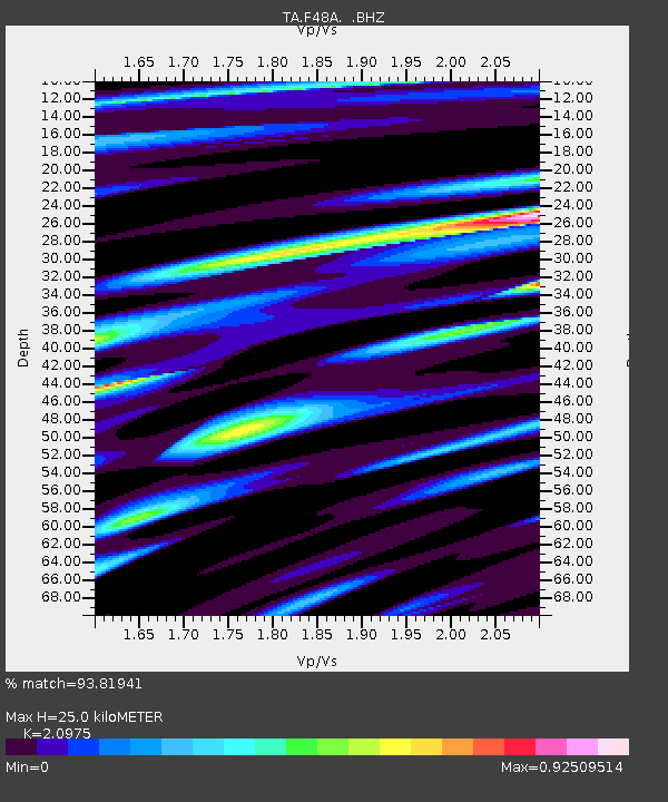
| Estimated Moho Depth: |
25.0 km |
| Estimated Crust Vp/Vs: |
2.10 |
| Assumed Crust Vp: |
6.483 km/s |
| Estimated Crust Vs: |
3.091 km/s |
| Estimated Crust Poisson's Ratio: |
0.35 |
|
| Radial Match: |
93.81941 % |
| Radial Bump: |
400 |
| Transverse Match: |
76.177956 % |
| Transverse Bump: |
400 |
| SOD ConfigId: |
626651 |
| Insert Time: |
2014-06-12 09:59:21.471 +0000 |
| GWidth: |
2.5 |
| Max Bumps: |
400 |
| Tol: |
0.001 |
|
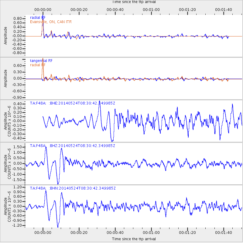
Signal To Noise
| Channel | StoN | STA | LTA |
| TA:F48A: :BHZ:20140524T08:30:42.349985Z | 10.800144 | 8.3358395E-7 | 7.718267E-8 |
| TA:F48A: :BHN:20140524T08:30:42.349985Z | 6.858689 | 5.014637E-7 | 7.311364E-8 |
| TA:F48A: :BHE:20140524T08:30:42.349985Z | 3.3574903 | 2.1628719E-7 | 6.4419304E-8 |
| Arrivals |
| Ps | 4.5 SECOND |
| PpPs | 11 SECOND |
| PsPs/PpSs | 16 SECOND |


