You are here: Home > Network List > TA - USArray Transportable Network (new EarthScope stations) Stations List
> Station F49A Sandfield, ON, CAN > Earthquake Result Viewer
F49A Sandfield, ON, CAN - Earthquake Result Viewer
| Earthquake location: |
Near Coast Of Guerrero, Mexico |
| Earthquake latitude/longitude: |
16.5/-98.1 |
| Earthquake time(UTC): |
2014/05/24 (144) 08:24:47 GMT |
| Earthquake Depth: |
17 km |
| Earthquake Magnitude: |
5.7 MWW, 5.6 MWB, 5.7 MWC |
| Earthquake Catalog/Contributor: |
NEIC PDE/NEIC COMCAT |
|
| Network: |
TA USArray Transportable Network (new EarthScope stations) |
| Station: |
F49A Sandfield, ON, CAN |
| Lat/Lon: |
45.76 N/82.04 W |
| Elevation: |
230 m |
|
| Distance: |
32.1 deg |
| Az: |
21.419 deg |
| Baz: |
210.025 deg |
| Ray Param: |
0.07877719 |
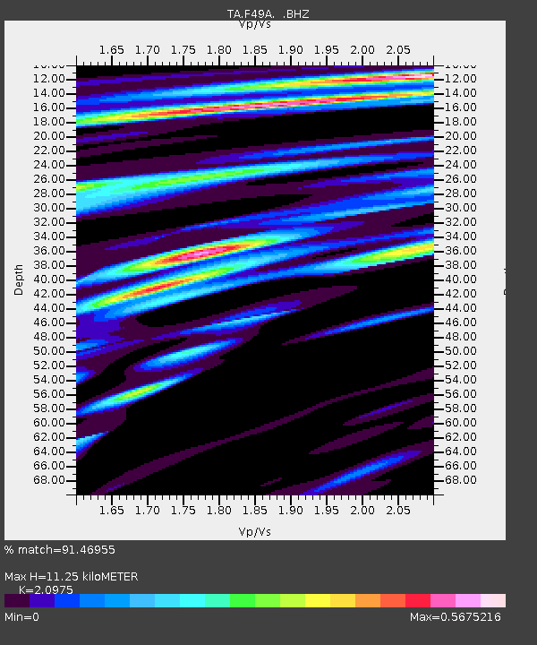
| Estimated Moho Depth: |
11.25 km |
| Estimated Crust Vp/Vs: |
2.10 |
| Assumed Crust Vp: |
6.483 km/s |
| Estimated Crust Vs: |
3.091 km/s |
| Estimated Crust Poisson's Ratio: |
0.35 |
|
| Radial Match: |
91.46955 % |
| Radial Bump: |
393 |
| Transverse Match: |
64.46726 % |
| Transverse Bump: |
400 |
| SOD ConfigId: |
626651 |
| Insert Time: |
2014-06-12 09:59:25.642 +0000 |
| GWidth: |
2.5 |
| Max Bumps: |
400 |
| Tol: |
0.001 |
|
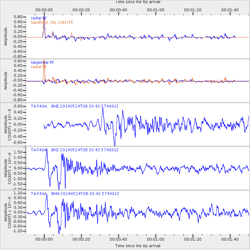
Signal To Noise
| Channel | StoN | STA | LTA |
| TA:F49A: :BHZ:20140524T08:30:43.574991Z | 11.867235 | 8.508111E-7 | 7.169413E-8 |
| TA:F49A: :BHN:20140524T08:30:43.574991Z | 5.0005164 | 5.032181E-7 | 1.00633216E-7 |
| TA:F49A: :BHE:20140524T08:30:43.574991Z | 3.962711 | 2.2269265E-7 | 5.6197045E-8 |
| Arrivals |
| Ps | 2.0 SECOND |
| PpPs | 5.0 SECOND |
| PsPs/PpSs | 7.1 SECOND |


