You are here: Home > Network List > TA - USArray Transportable Network (new EarthScope stations) Stations List
> Station F51A Arnstein, ON, CAN > Earthquake Result Viewer
F51A Arnstein, ON, CAN - Earthquake Result Viewer
| Earthquake location: |
Near Coast Of Guerrero, Mexico |
| Earthquake latitude/longitude: |
16.5/-98.1 |
| Earthquake time(UTC): |
2014/05/24 (144) 08:24:47 GMT |
| Earthquake Depth: |
17 km |
| Earthquake Magnitude: |
5.7 MWW, 5.6 MWB, 5.7 MWC |
| Earthquake Catalog/Contributor: |
NEIC PDE/NEIC COMCAT |
|
| Network: |
TA USArray Transportable Network (new EarthScope stations) |
| Station: |
F51A Arnstein, ON, CAN |
| Lat/Lon: |
45.93 N/79.92 W |
| Elevation: |
239 m |
|
| Distance: |
33.0 deg |
| Az: |
23.607 deg |
| Baz: |
213.391 deg |
| Ray Param: |
0.0783798 |
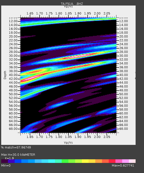
| Estimated Moho Depth: |
30.0 km |
| Estimated Crust Vp/Vs: |
1.90 |
| Assumed Crust Vp: |
6.577 km/s |
| Estimated Crust Vs: |
3.462 km/s |
| Estimated Crust Poisson's Ratio: |
0.31 |
|
| Radial Match: |
87.96749 % |
| Radial Bump: |
368 |
| Transverse Match: |
72.65839 % |
| Transverse Bump: |
400 |
| SOD ConfigId: |
626651 |
| Insert Time: |
2014-06-12 09:59:28.773 +0000 |
| GWidth: |
2.5 |
| Max Bumps: |
400 |
| Tol: |
0.001 |
|

Signal To Noise
| Channel | StoN | STA | LTA |
| TA:F51A: :BHZ:20140524T08:30:51.650004Z | 9.401899 | 5.757518E-7 | 6.123782E-8 |
| TA:F51A: :BHN:20140524T08:30:51.650004Z | 5.492077 | 3.606443E-7 | 6.566629E-8 |
| TA:F51A: :BHE:20140524T08:30:51.650004Z | 6.3489914 | 2.790212E-7 | 4.3947328E-8 |
| Arrivals |
| Ps | 4.4 SECOND |
| PpPs | 12 SECOND |
| PsPs/PpSs | 17 SECOND |


