You are here: Home > Network List > TA - USArray Transportable Network (new EarthScope stations) Stations List
> Station F52A Sundridge, ON, CAN > Earthquake Result Viewer
F52A Sundridge, ON, CAN - Earthquake Result Viewer
| Earthquake location: |
Near Coast Of Guerrero, Mexico |
| Earthquake latitude/longitude: |
16.5/-98.1 |
| Earthquake time(UTC): |
2014/05/24 (144) 08:24:47 GMT |
| Earthquake Depth: |
17 km |
| Earthquake Magnitude: |
5.7 MWW, 5.6 MWB, 5.7 MWC |
| Earthquake Catalog/Contributor: |
NEIC PDE/NEIC COMCAT |
|
| Network: |
TA USArray Transportable Network (new EarthScope stations) |
| Station: |
F52A Sundridge, ON, CAN |
| Lat/Lon: |
45.80 N/79.32 W |
| Elevation: |
351 m |
|
| Distance: |
33.2 deg |
| Az: |
24.372 deg |
| Baz: |
214.456 deg |
| Ray Param: |
0.078323685 |
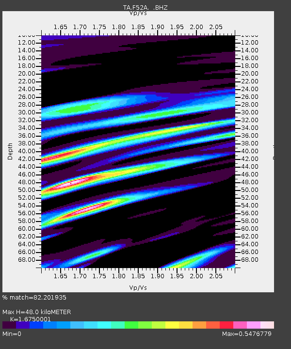
| Estimated Moho Depth: |
48.0 km |
| Estimated Crust Vp/Vs: |
1.68 |
| Assumed Crust Vp: |
6.577 km/s |
| Estimated Crust Vs: |
3.927 km/s |
| Estimated Crust Poisson's Ratio: |
0.22 |
|
| Radial Match: |
82.201935 % |
| Radial Bump: |
369 |
| Transverse Match: |
57.940742 % |
| Transverse Bump: |
400 |
| SOD ConfigId: |
626651 |
| Insert Time: |
2014-06-12 09:59:33.016 +0000 |
| GWidth: |
2.5 |
| Max Bumps: |
400 |
| Tol: |
0.001 |
|
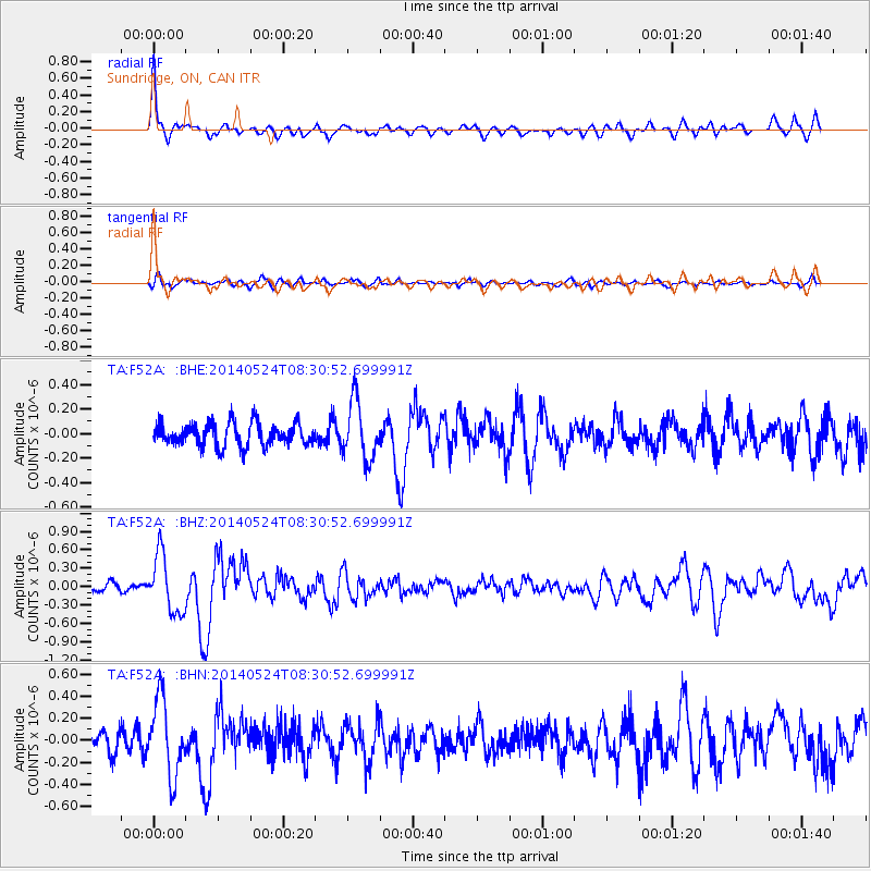
Signal To Noise
| Channel | StoN | STA | LTA |
| TA:F52A: :BHZ:20140524T08:30:52.699991Z | 5.9566617 | 4.7269552E-7 | 7.935578E-8 |
| TA:F52A: :BHN:20140524T08:30:52.699991Z | 3.9380457 | 3.4021184E-7 | 8.639103E-8 |
| TA:F52A: :BHE:20140524T08:30:52.699991Z | 2.531093 | 2.3646771E-7 | 9.3425136E-8 |
| Arrivals |
| Ps | 5.4 SECOND |
| PpPs | 18 SECOND |
| PsPs/PpSs | 23 SECOND |


