You are here: Home > Network List > TA - USArray Transportable Network (new EarthScope stations) Stations List
> Station G46A Petoskey, MI, USA > Earthquake Result Viewer
G46A Petoskey, MI, USA - Earthquake Result Viewer
| Earthquake location: |
Near Coast Of Guerrero, Mexico |
| Earthquake latitude/longitude: |
16.5/-98.1 |
| Earthquake time(UTC): |
2014/05/24 (144) 08:24:47 GMT |
| Earthquake Depth: |
17 km |
| Earthquake Magnitude: |
5.7 MWW, 5.6 MWB, 5.7 MWC |
| Earthquake Catalog/Contributor: |
NEIC PDE/NEIC COMCAT |
|
| Network: |
TA USArray Transportable Network (new EarthScope stations) |
| Station: |
G46A Petoskey, MI, USA |
| Lat/Lon: |
45.32 N/84.86 W |
| Elevation: |
239 m |
|
| Distance: |
30.8 deg |
| Az: |
18.455 deg |
| Baz: |
205.491 deg |
| Ray Param: |
0.079230115 |
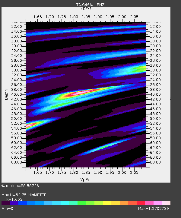
| Estimated Moho Depth: |
52.75 km |
| Estimated Crust Vp/Vs: |
1.61 |
| Assumed Crust Vp: |
6.483 km/s |
| Estimated Crust Vs: |
4.039 km/s |
| Estimated Crust Poisson's Ratio: |
0.18 |
|
| Radial Match: |
88.58726 % |
| Radial Bump: |
400 |
| Transverse Match: |
72.74427 % |
| Transverse Bump: |
400 |
| SOD ConfigId: |
626651 |
| Insert Time: |
2014-06-12 10:00:19.514 +0000 |
| GWidth: |
2.5 |
| Max Bumps: |
400 |
| Tol: |
0.001 |
|

Signal To Noise
| Channel | StoN | STA | LTA |
| TA:G46A: :BHZ:20140524T08:30:32.00001Z | 10.052012 | 9.823915E-7 | 9.7730826E-8 |
| TA:G46A: :BHN:20140524T08:30:32.00001Z | 5.9202185 | 7.146163E-7 | 1.2070775E-7 |
| TA:G46A: :BHE:20140524T08:30:32.00001Z | 2.2641115 | 3.0970267E-7 | 1.3678773E-7 |
| Arrivals |
| Ps | 5.4 SECOND |
| PpPs | 19 SECOND |
| PsPs/PpSs | 25 SECOND |


