You are here: Home > Network List > TA - USArray Transportable Network (new EarthScope stations) Stations List
> Station G60A Masonville, QC, CAN > Earthquake Result Viewer
G60A Masonville, QC, CAN - Earthquake Result Viewer
| Earthquake location: |
Near Coast Of Guerrero, Mexico |
| Earthquake latitude/longitude: |
16.5/-98.1 |
| Earthquake time(UTC): |
2014/05/24 (144) 08:24:47 GMT |
| Earthquake Depth: |
17 km |
| Earthquake Magnitude: |
5.7 MWW, 5.6 MWB, 5.7 MWC |
| Earthquake Catalog/Contributor: |
NEIC PDE/NEIC COMCAT |
|
| Network: |
TA USArray Transportable Network (new EarthScope stations) |
| Station: |
G60A Masonville, QC, CAN |
| Lat/Lon: |
45.10 N/72.33 W |
| Elevation: |
391 m |
|
| Distance: |
35.8 deg |
| Az: |
31.822 deg |
| Baz: |
225.569 deg |
| Ray Param: |
0.07701779 |
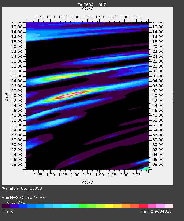
| Estimated Moho Depth: |
39.5 km |
| Estimated Crust Vp/Vs: |
1.78 |
| Assumed Crust Vp: |
6.419 km/s |
| Estimated Crust Vs: |
3.611 km/s |
| Estimated Crust Poisson's Ratio: |
0.27 |
|
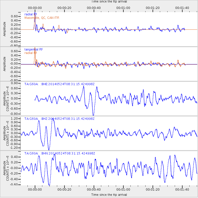
| Radial Match: |
85.750336 % |
| Radial Bump: |
400 |
| Transverse Match: |
65.81451 % |
| Transverse Bump: |
400 |
| SOD ConfigId: |
626651 |
| Insert Time: |
2014-06-12 10:00:46.978 +0000 |
| GWidth: |
2.5 |
| Max Bumps: |
400 |
| Tol: |
0.001 |
|
Signal To Noise
| Channel | StoN | STA | LTA |
| TA:G60A: :BHZ:20140524T08:31:15.424998Z | 4.407513 | 5.344651E-7 | 1.2126227E-7 |
| TA:G60A: :BHN:20140524T08:31:15.424998Z | 3.0868964 | 2.4665624E-7 | 7.990428E-8 |
| TA:G60A: :BHE:20140524T08:31:15.424998Z | 3.1584795 | 3.4754856E-7 | 1.1003667E-7 |
| Arrivals |
| Ps | 5.2 SECOND |
| PpPs | 16 SECOND |
| PsPs/PpSs | 21 SECOND |


