You are here: Home > Network List > TA - USArray Transportable Network (new EarthScope stations) Stations List
> Station H53A Bobcaygeon, ON, CAN > Earthquake Result Viewer
H53A Bobcaygeon, ON, CAN - Earthquake Result Viewer
| Earthquake location: |
Near Coast Of Guerrero, Mexico |
| Earthquake latitude/longitude: |
16.5/-98.1 |
| Earthquake time(UTC): |
2014/05/24 (144) 08:24:47 GMT |
| Earthquake Depth: |
17 km |
| Earthquake Magnitude: |
5.7 MWW, 5.6 MWB, 5.7 MWC |
| Earthquake Catalog/Contributor: |
NEIC PDE/NEIC COMCAT |
|
| Network: |
TA USArray Transportable Network (new EarthScope stations) |
| Station: |
H53A Bobcaygeon, ON, CAN |
| Lat/Lon: |
44.57 N/78.58 W |
| Elevation: |
292 m |
|
| Distance: |
32.5 deg |
| Az: |
26.469 deg |
| Baz: |
216.741 deg |
| Ray Param: |
0.07862663 |
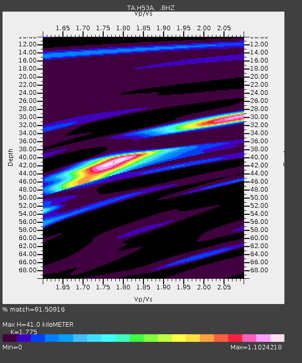
| Estimated Moho Depth: |
41.0 km |
| Estimated Crust Vp/Vs: |
1.77 |
| Assumed Crust Vp: |
6.577 km/s |
| Estimated Crust Vs: |
3.705 km/s |
| Estimated Crust Poisson's Ratio: |
0.27 |
|
| Radial Match: |
91.50916 % |
| Radial Bump: |
351 |
| Transverse Match: |
60.674088 % |
| Transverse Bump: |
400 |
| SOD ConfigId: |
626651 |
| Insert Time: |
2014-06-12 10:01:26.843 +0000 |
| GWidth: |
2.5 |
| Max Bumps: |
400 |
| Tol: |
0.001 |
|
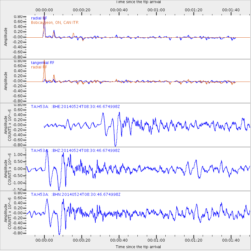
Signal To Noise
| Channel | StoN | STA | LTA |
| TA:H53A: :BHZ:20140524T08:30:46.674998Z | 7.0653844 | 7.266121E-7 | 1.0284113E-7 |
| TA:H53A: :BHN:20140524T08:30:46.674998Z | 5.9642878 | 3.019728E-7 | 5.0630153E-8 |
| TA:H53A: :BHE:20140524T08:30:46.674998Z | 3.6015882 | 2.5983675E-7 | 7.214504E-8 |
| Arrivals |
| Ps | 5.2 SECOND |
| PpPs | 16 SECOND |
| PsPs/PpSs | 21 SECOND |


