You are here: Home > Network List > TA - USArray Transportable Network (new EarthScope stations) Stations List
> Station I57A Carthage, NY, USA > Earthquake Result Viewer
I57A Carthage, NY, USA - Earthquake Result Viewer
| Earthquake location: |
Near Coast Of Guerrero, Mexico |
| Earthquake latitude/longitude: |
16.5/-98.1 |
| Earthquake time(UTC): |
2014/05/24 (144) 08:24:47 GMT |
| Earthquake Depth: |
17 km |
| Earthquake Magnitude: |
5.7 MWW, 5.6 MWB, 5.7 MWC |
| Earthquake Catalog/Contributor: |
NEIC PDE/NEIC COMCAT |
|
| Network: |
TA USArray Transportable Network (new EarthScope stations) |
| Station: |
I57A Carthage, NY, USA |
| Lat/Lon: |
43.94 N/75.66 W |
| Elevation: |
321 m |
|
| Distance: |
33.3 deg |
| Az: |
30.204 deg |
| Baz: |
221.911 deg |
| Ray Param: |
0.07825418 |
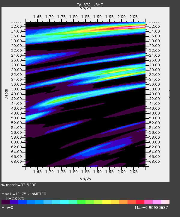
| Estimated Moho Depth: |
11.75 km |
| Estimated Crust Vp/Vs: |
2.10 |
| Assumed Crust Vp: |
6.419 km/s |
| Estimated Crust Vs: |
3.06 km/s |
| Estimated Crust Poisson's Ratio: |
0.35 |
|
| Radial Match: |
87.5288 % |
| Radial Bump: |
366 |
| Transverse Match: |
63.64155 % |
| Transverse Bump: |
400 |
| SOD ConfigId: |
626651 |
| Insert Time: |
2014-06-12 10:02:52.666 +0000 |
| GWidth: |
2.5 |
| Max Bumps: |
400 |
| Tol: |
0.001 |
|

Signal To Noise
| Channel | StoN | STA | LTA |
| TA:I57A: :BHZ:20140524T08:30:54.00001Z | 9.163725 | 5.458812E-7 | 5.9569793E-8 |
| TA:I57A: :BHN:20140524T08:30:54.00001Z | 4.694117 | 2.5260206E-7 | 5.3812478E-8 |
| TA:I57A: :BHE:20140524T08:30:54.00001Z | 3.3947017 | 2.2574964E-7 | 6.650058E-8 |
| Arrivals |
| Ps | 2.1 SECOND |
| PpPs | 5.3 SECOND |
| PsPs/PpSs | 7.5 SECOND |


