You are here: Home > Network List > TA - USArray Transportable Network (new EarthScope stations) Stations List
> Station K58A Earlville, NY, USA > Earthquake Result Viewer
K58A Earlville, NY, USA - Earthquake Result Viewer
| Earthquake location: |
Near Coast Of Guerrero, Mexico |
| Earthquake latitude/longitude: |
16.5/-98.1 |
| Earthquake time(UTC): |
2014/05/24 (144) 08:24:47 GMT |
| Earthquake Depth: |
17 km |
| Earthquake Magnitude: |
5.7 MWW, 5.6 MWB, 5.7 MWC |
| Earthquake Catalog/Contributor: |
NEIC PDE/NEIC COMCAT |
|
| Network: |
TA USArray Transportable Network (new EarthScope stations) |
| Station: |
K58A Earlville, NY, USA |
| Lat/Lon: |
42.76 N/75.65 W |
| Elevation: |
509 m |
|
| Distance: |
32.4 deg |
| Az: |
31.679 deg |
| Baz: |
223.159 deg |
| Ray Param: |
0.078634694 |
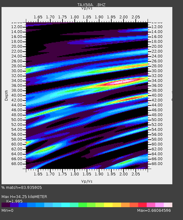
| Estimated Moho Depth: |
34.25 km |
| Estimated Crust Vp/Vs: |
2.00 |
| Assumed Crust Vp: |
6.419 km/s |
| Estimated Crust Vs: |
3.218 km/s |
| Estimated Crust Poisson's Ratio: |
0.33 |
|
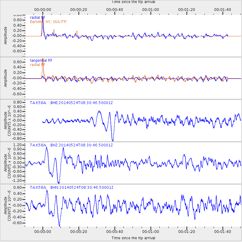
| Radial Match: |
83.935905 % |
| Radial Bump: |
400 |
| Transverse Match: |
55.790615 % |
| Transverse Bump: |
400 |
| SOD ConfigId: |
626651 |
| Insert Time: |
2014-06-12 10:04:58.112 +0000 |
| GWidth: |
2.5 |
| Max Bumps: |
400 |
| Tol: |
0.001 |
|
Signal To Noise
| Channel | StoN | STA | LTA |
| TA:K58A: :BHZ:20140524T08:30:46.50001Z | 5.9793067 | 5.688287E-7 | 9.513288E-8 |
| TA:K58A: :BHN:20140524T08:30:46.50001Z | 2.616895 | 2.412174E-7 | 9.2176954E-8 |
| TA:K58A: :BHE:20140524T08:30:46.50001Z | 5.4100976 | 2.6508042E-7 | 4.8997343E-8 |
| Arrivals |
| Ps | 5.7 SECOND |
| PpPs | 15 SECOND |
| PsPs/PpSs | 21 SECOND |


