You are here: Home > Network List > TA - USArray Transportable Network (new EarthScope stations) Stations List
> Station K59A Cooperstown, NY, USA > Earthquake Result Viewer
K59A Cooperstown, NY, USA - Earthquake Result Viewer

| Earthquake location: |
Near Coast Of Guerrero, Mexico |
| Earthquake latitude/longitude: |
16.5/-98.1 |
| Earthquake time(UTC): |
2014/05/24 (144) 08:24:47 GMT |
| Earthquake Depth: |
17 km |
| Earthquake Magnitude: |
5.7 MWW, 5.6 MWB, 5.7 MWC |
| Earthquake Catalog/Contributor: |
NEIC PDE/NEIC COMCAT |
|
| Network: |
TA USArray Transportable Network (new EarthScope stations) |
| Station: |
K59A Cooperstown, NY, USA |
| Lat/Lon: |
42.78 N/74.85 W |
| Elevation: |
570 m |
|
| Distance: |
32.9 deg |
| Az: |
32.447 deg |
| Baz: |
224.343 deg |
| Ray Param: |
0.07845903 |
| Estimated Moho Depth: |
26.25 km |
| Estimated Crust Vp/Vs: |
1.85 |
| Assumed Crust Vp: |
6.419 km/s |
| Estimated Crust Vs: |
3.47 km/s |
| Estimated Crust Poisson's Ratio: |
0.29 |
|
| Radial Match: |
81.38425 % |
| Radial Bump: |
400 |
| Transverse Match: |
66.438286 % |
| Transverse Bump: |
400 |
| SOD ConfigId: |
626651 |
| Insert Time: |
2014-06-12 10:04:58.447 +0000 |
| GWidth: |
2.5 |
| Max Bumps: |
400 |
| Tol: |
0.001 |
|
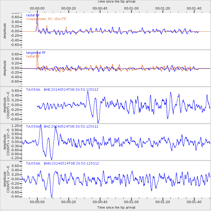
Signal To Noise
| Channel | StoN | STA | LTA |
| TA:K59A: :BHZ:20140524T08:30:50.12501Z | 7.360283 | 6.590858E-7 | 8.954626E-8 |
| TA:K59A: :BHN:20140524T08:30:50.12501Z | 2.35304 | 1.9788592E-7 | 8.409799E-8 |
| TA:K59A: :BHE:20140524T08:30:50.12501Z | 3.6805356 | 2.762063E-7 | 7.5045136E-8 |
| Arrivals |
| Ps | 3.7 SECOND |
| PpPs | 11 SECOND |
| PsPs/PpSs | 15 SECOND |


