You are here: Home > Network List > TA - USArray Transportable Network (new EarthScope stations) Stations List
> Station K61A Williamstown, MA, USA > Earthquake Result Viewer
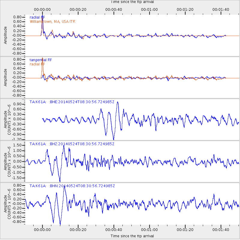
K61A Williamstown, MA, USA - Earthquake Result Viewer

| Earthquake location: |
Near Coast Of Guerrero, Mexico |
| Earthquake latitude/longitude: |
16.5/-98.1 |
| Earthquake time(UTC): |
2014/05/24 (144) 08:24:47 GMT |
| Earthquake Depth: |
17 km |
| Earthquake Magnitude: |
5.7 MWW, 5.6 MWB, 5.7 MWC |
| Earthquake Catalog/Contributor: |
NEIC PDE/NEIC COMCAT |
|
| Network: |
TA USArray Transportable Network (new EarthScope stations) |
| Station: |
K61A Williamstown, MA, USA |
| Lat/Lon: |
42.67 N/73.27 W |
| Elevation: |
391 m |
|
| Distance: |
33.6 deg |
| Az: |
34.077 deg |
| Baz: |
226.778 deg |
| Ray Param: |
0.07810943 |
| Estimated Moho Depth: |
46.75 km |
| Estimated Crust Vp/Vs: |
1.62 |
| Assumed Crust Vp: |
6.419 km/s |
| Estimated Crust Vs: |
3.969 km/s |
| Estimated Crust Poisson's Ratio: |
0.19 |
|
| Radial Match: |
92.69469 % |
| Radial Bump: |
379 |
| Transverse Match: |
71.40947 % |
| Transverse Bump: |
400 |
| SOD ConfigId: |
626651 |
| Insert Time: |
2014-06-12 10:05:06.082 +0000 |
| GWidth: |
2.5 |
| Max Bumps: |
400 |
| Tol: |
0.001 |
|
Signal To Noise
| Channel | StoN | STA | LTA |
| TA:K61A: :BHZ:20140524T08:30:56.724985Z | 4.7801824 | 4.846123E-7 | 1.0137946E-7 |
| TA:K61A: :BHN:20140524T08:30:56.724985Z | 2.3565357 | 1.9633553E-7 | 8.331533E-8 |
| TA:K61A: :BHE:20140524T08:30:56.724985Z | 3.0334082 | 2.9305963E-7 | 9.6610684E-8 |
| Arrivals |
| Ps | 4.9 SECOND |
| PpPs | 18 SECOND |
| PsPs/PpSs | 22 SECOND |


