You are here: Home > Network List > TA - USArray Transportable Network (new EarthScope stations) Stations List
> Station L58A Harry Jones Memorial, Binghamton, NY, USA > Earthquake Result Viewer
L58A Harry Jones Memorial, Binghamton, NY, USA - Earthquake Result Viewer
| Earthquake location: |
Near Coast Of Guerrero, Mexico |
| Earthquake latitude/longitude: |
16.5/-98.1 |
| Earthquake time(UTC): |
2014/05/24 (144) 08:24:47 GMT |
| Earthquake Depth: |
17 km |
| Earthquake Magnitude: |
5.7 MWW, 5.6 MWB, 5.7 MWC |
| Earthquake Catalog/Contributor: |
NEIC PDE/NEIC COMCAT |
|
| Network: |
TA USArray Transportable Network (new EarthScope stations) |
| Station: |
L58A Harry Jones Memorial, Binghamton, NY, USA |
| Lat/Lon: |
42.04 N/75.85 W |
| Elevation: |
447 m |
|
| Distance: |
31.8 deg |
| Az: |
32.401 deg |
| Baz: |
223.634 deg |
| Ray Param: |
0.07890046 |
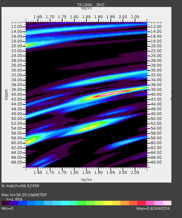
| Estimated Moho Depth: |
39.25 km |
| Estimated Crust Vp/Vs: |
1.96 |
| Assumed Crust Vp: |
6.419 km/s |
| Estimated Crust Vs: |
3.283 km/s |
| Estimated Crust Poisson's Ratio: |
0.32 |
|
| Radial Match: |
86.52459 % |
| Radial Bump: |
379 |
| Transverse Match: |
71.39216 % |
| Transverse Bump: |
400 |
| SOD ConfigId: |
626651 |
| Insert Time: |
2014-06-12 10:05:35.702 +0000 |
| GWidth: |
2.5 |
| Max Bumps: |
400 |
| Tol: |
0.001 |
|
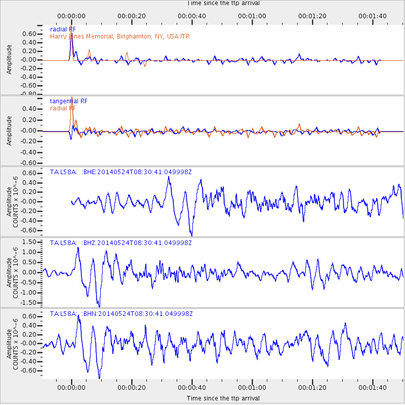
Signal To Noise
| Channel | StoN | STA | LTA |
| TA:L58A: :BHZ:20140524T08:30:41.049998Z | 3.430862 | 5.85283E-7 | 1.7059357E-7 |
| TA:L58A: :BHN:20140524T08:30:41.049998Z | 4.5565825 | 3.0318193E-7 | 6.653713E-8 |
| TA:L58A: :BHE:20140524T08:30:41.049998Z | 2.8725302 | 2.522291E-7 | 8.7807294E-8 |
| Arrivals |
| Ps | 6.3 SECOND |
| PpPs | 17 SECOND |
| PsPs/PpSs | 23 SECOND |


