You are here: Home > Network List > TA - USArray Transportable Network (new EarthScope stations) Stations List
> Station M63A Gales Ferry, CT, USA > Earthquake Result Viewer
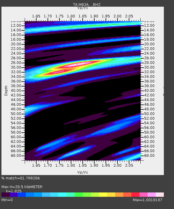
M63A Gales Ferry, CT, USA - Earthquake Result Viewer
| Earthquake location: |
Near Coast Of Guerrero, Mexico |
| Earthquake latitude/longitude: |
16.5/-98.1 |
| Earthquake time(UTC): |
2014/05/24 (144) 08:24:47 GMT |
| Earthquake Depth: |
17 km |
| Earthquake Magnitude: |
5.7 MWW, 5.6 MWB, 5.7 MWC |
| Earthquake Catalog/Contributor: |
NEIC PDE/NEIC COMCAT |
|
| Network: |
TA USArray Transportable Network (new EarthScope stations) |
| Station: |
M63A Gales Ferry, CT, USA |
| Lat/Lon: |
41.40 N/72.05 W |
| Elevation: |
44 m |
|
| Distance: |
33.5 deg |
| Az: |
36.882 deg |
| Baz: |
229.93 deg |
| Ray Param: |
0.07818339 |
| Estimated Moho Depth: |
28.5 km |
| Estimated Crust Vp/Vs: |
1.83 |
| Assumed Crust Vp: |
6.472 km/s |
| Estimated Crust Vs: |
3.546 km/s |
| Estimated Crust Poisson's Ratio: |
0.29 |
|
| Radial Match: |
81.799286 % |
| Radial Bump: |
392 |
| Transverse Match: |
64.998825 % |
| Transverse Bump: |
400 |
| SOD ConfigId: |
626651 |
| Insert Time: |
2014-06-12 10:06:40.206 +0000 |
| GWidth: |
2.5 |
| Max Bumps: |
400 |
| Tol: |
0.001 |
|

Signal To Noise
| Channel | StoN | STA | LTA |
| TA:M63A: :BHZ:20140524T08:30:55.349985Z | 5.4462385 | 7.7093233E-7 | 1.4155317E-7 |
| TA:M63A: :BHN:20140524T08:30:55.349985Z | 3.0677633 | 3.9609898E-7 | 1.2911653E-7 |
| TA:M63A: :BHE:20140524T08:30:55.349985Z | 3.0380716 | 4.108759E-7 | 1.3524233E-7 |
| Arrivals |
| Ps | 3.9 SECOND |
| PpPs | 12 SECOND |
| PsPs/PpSs | 15 SECOND |


