You are here: Home > Network List > TA - USArray Transportable Network (new EarthScope stations) Stations List
> Station N60A Cedar Hill Farm, Mount Bethel, PA, USA > Earthquake Result Viewer
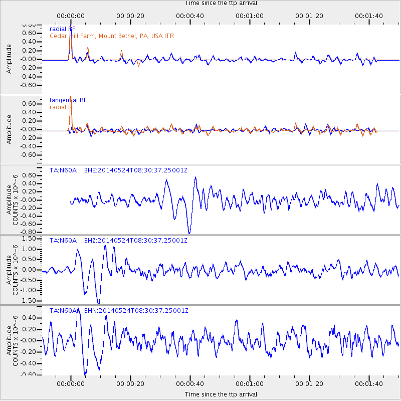
N60A Cedar Hill Farm, Mount Bethel, PA, USA - Earthquake Result Viewer

| Earthquake location: |
Near Coast Of Guerrero, Mexico |
| Earthquake latitude/longitude: |
16.5/-98.1 |
| Earthquake time(UTC): |
2014/05/24 (144) 08:24:47 GMT |
| Earthquake Depth: |
17 km |
| Earthquake Magnitude: |
5.7 MWW, 5.6 MWB, 5.7 MWC |
| Earthquake Catalog/Contributor: |
NEIC PDE/NEIC COMCAT |
|
| Network: |
TA USArray Transportable Network (new EarthScope stations) |
| Station: |
N60A Cedar Hill Farm, Mount Bethel, PA, USA |
| Lat/Lon: |
40.87 N/75.10 W |
| Elevation: |
189 m |
|
| Distance: |
31.4 deg |
| Az: |
34.744 deg |
| Baz: |
226.124 deg |
| Ray Param: |
0.079074174 |
| Estimated Moho Depth: |
55.75 km |
| Estimated Crust Vp/Vs: |
2.09 |
| Assumed Crust Vp: |
6.283 km/s |
| Estimated Crust Vs: |
3.01 km/s |
| Estimated Crust Poisson's Ratio: |
0.35 |
|
| Radial Match: |
83.669945 % |
| Radial Bump: |
378 |
| Transverse Match: |
58.919872 % |
| Transverse Bump: |
400 |
| SOD ConfigId: |
626651 |
| Insert Time: |
2014-06-12 10:07:05.962 +0000 |
| GWidth: |
2.5 |
| Max Bumps: |
400 |
| Tol: |
0.001 |
|
Signal To Noise
| Channel | StoN | STA | LTA |
| TA:N60A: :BHZ:20140524T08:30:37.25001Z | 6.505504 | 5.8396756E-7 | 8.9765145E-8 |
| TA:N60A: :BHN:20140524T08:30:37.25001Z | 2.9596722 | 3.2476305E-7 | 1.097294E-7 |
| TA:N60A: :BHE:20140524T08:30:37.25001Z | 3.3199186 | 2.696179E-7 | 8.121221E-8 |
| Arrivals |
| Ps | 10 SECOND |
| PpPs | 26 SECOND |
| PsPs/PpSs | 36 SECOND |


