You are here: Home > Network List > TA - USArray Transportable Network (new EarthScope stations) Stations List
> Station O02D Mt. Diablo Meridian, CA, USA > Earthquake Result Viewer
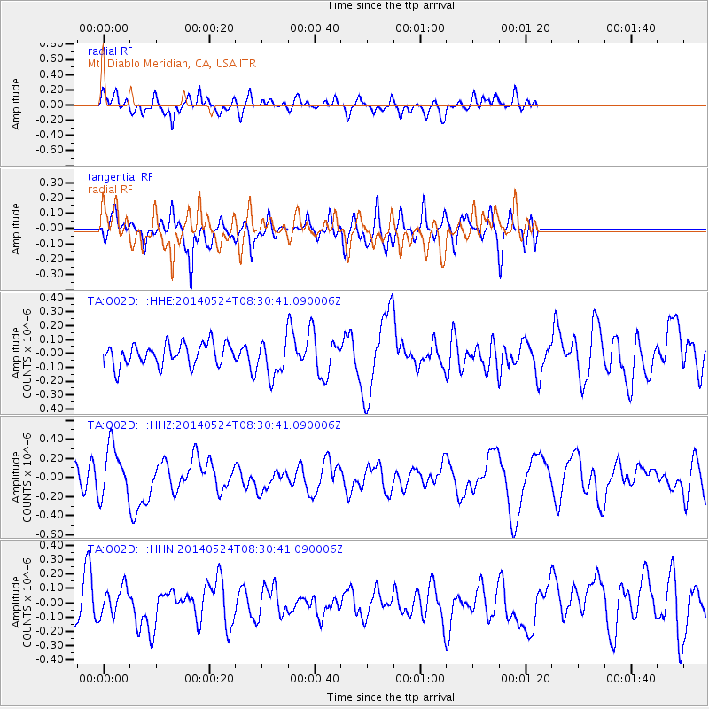
O02D Mt. Diablo Meridian, CA, USA - Earthquake Result Viewer
*The percent match for this event was below the threshold and hence no stack was calculated.
| Earthquake location: |
Near Coast Of Guerrero, Mexico |
| Earthquake latitude/longitude: |
16.5/-98.1 |
| Earthquake time(UTC): |
2014/05/24 (144) 08:24:47 GMT |
| Earthquake Depth: |
17 km |
| Earthquake Magnitude: |
5.7 MWW, 5.6 MWB, 5.7 MWC |
| Earthquake Catalog/Contributor: |
NEIC PDE/NEIC COMCAT |
|
| Network: |
TA USArray Transportable Network (new EarthScope stations) |
| Station: |
O02D Mt. Diablo Meridian, CA, USA |
| Lat/Lon: |
40.18 N/122.79 W |
| Elevation: |
965 m |
|
| Distance: |
31.8 deg |
| Az: |
322.706 deg |
| Baz: |
130.664 deg |
| Ray Param: |
$rayparam |
*The percent match for this event was below the threshold and hence was not used in the summary stack. |
|
| Radial Match: |
75.62774 % |
| Radial Bump: |
400 |
| Transverse Match: |
66.18772 % |
| Transverse Bump: |
373 |
| SOD ConfigId: |
626651 |
| Insert Time: |
2014-06-12 10:07:19.040 +0000 |
| GWidth: |
2.5 |
| Max Bumps: |
400 |
| Tol: |
0.001 |
|
Signal To Noise
| Channel | StoN | STA | LTA |
| TA:O02D: :HHZ:20140524T08:30:41.090006Z | 3.4728081 | 2.6765912E-7 | 7.707282E-8 |
| TA:O02D: :HHN:20140524T08:30:41.090006Z | 1.0346171 | 9.82914E-8 | 9.500268E-8 |
| TA:O02D: :HHE:20140524T08:30:41.090006Z | 1.6629674 | 1.2959919E-7 | 7.7932484E-8 |
| Arrivals |
| Ps | |
| PpPs | |
| PsPs/PpSs | |


