You are here: Home > Network List > TA - USArray Transportable Network (new EarthScope stations) Stations List
> Station P61A Hammonton, NJ, USA > Earthquake Result Viewer
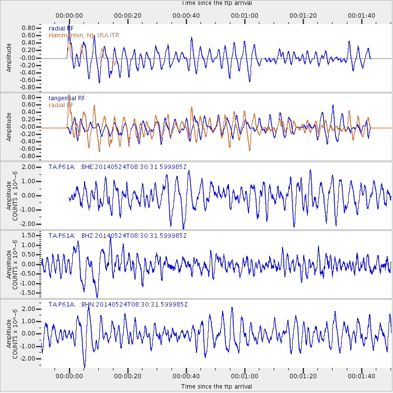
P61A Hammonton, NJ, USA - Earthquake Result Viewer
*The percent match for this event was below the threshold and hence no stack was calculated.
| Earthquake location: |
Near Coast Of Guerrero, Mexico |
| Earthquake latitude/longitude: |
16.5/-98.1 |
| Earthquake time(UTC): |
2014/05/24 (144) 08:24:47 GMT |
| Earthquake Depth: |
17 km |
| Earthquake Magnitude: |
5.7 MWW, 5.6 MWB, 5.7 MWC |
| Earthquake Catalog/Contributor: |
NEIC PDE/NEIC COMCAT |
|
| Network: |
TA USArray Transportable Network (new EarthScope stations) |
| Station: |
P61A Hammonton, NJ, USA |
| Lat/Lon: |
39.67 N/74.79 W |
| Elevation: |
22 m |
|
| Distance: |
30.7 deg |
| Az: |
36.751 deg |
| Baz: |
228.042 deg |
| Ray Param: |
$rayparam |
*The percent match for this event was below the threshold and hence was not used in the summary stack. |
|
| Radial Match: |
67.00274 % |
| Radial Bump: |
400 |
| Transverse Match: |
63.23959 % |
| Transverse Bump: |
400 |
| SOD ConfigId: |
626651 |
| Insert Time: |
2014-06-12 10:07:41.083 +0000 |
| GWidth: |
2.5 |
| Max Bumps: |
400 |
| Tol: |
0.001 |
|
Signal To Noise
| Channel | StoN | STA | LTA |
| TA:P61A: :BHZ:20140524T08:30:31.599985Z | 2.2931674 | 7.0979524E-7 | 3.0952614E-7 |
| TA:P61A: :BHN:20140524T08:30:31.599985Z | 1.2690299 | 7.5705094E-7 | 5.965588E-7 |
| TA:P61A: :BHE:20140524T08:30:31.599985Z | 1.6535687 | 9.352062E-7 | 5.6556837E-7 |
| Arrivals |
| Ps | |
| PpPs | |
| PsPs/PpSs | |


