You are here: Home > Network List > US - United States National Seismic Network Stations List
> Station HAWA Hanford, Washington, USA > Earthquake Result Viewer
HAWA Hanford, Washington, USA - Earthquake Result Viewer
*The percent match for this event was below the threshold and hence no stack was calculated.
| Earthquake location: |
Near Coast Of Guerrero, Mexico |
| Earthquake latitude/longitude: |
16.5/-98.1 |
| Earthquake time(UTC): |
2014/05/24 (144) 08:24:47 GMT |
| Earthquake Depth: |
17 km |
| Earthquake Magnitude: |
5.7 MWW, 5.6 MWB, 5.7 MWC |
| Earthquake Catalog/Contributor: |
NEIC PDE/NEIC COMCAT |
|
| Network: |
US United States National Seismic Network |
| Station: |
HAWA Hanford, Washington, USA |
| Lat/Lon: |
46.39 N/119.53 W |
| Elevation: |
364 m |
|
| Distance: |
34.7 deg |
| Az: |
333.67 deg |
| Baz: |
142.072 deg |
| Ray Param: |
$rayparam |
*The percent match for this event was below the threshold and hence was not used in the summary stack. |
|
| Radial Match: |
75.47008 % |
| Radial Bump: |
400 |
| Transverse Match: |
64.79065 % |
| Transverse Bump: |
400 |
| SOD ConfigId: |
626651 |
| Insert Time: |
2014-06-12 10:08:32.944 +0000 |
| GWidth: |
2.5 |
| Max Bumps: |
400 |
| Tol: |
0.001 |
|
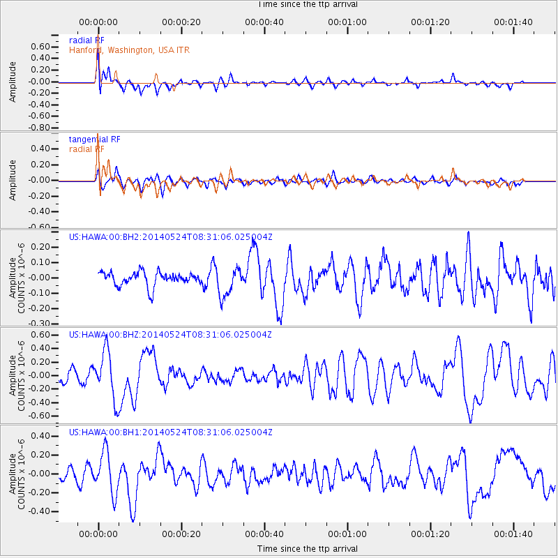
Signal To Noise
| Channel | StoN | STA | LTA |
| US:HAWA:00:BHZ:20140524T08:31:06.025004Z | 5.3463707 | 3.6677693E-7 | 6.860297E-8 |
| US:HAWA:00:BH1:20140524T08:31:06.025004Z | 3.3131626 | 2.2626925E-7 | 6.829404E-8 |
| US:HAWA:00:BH2:20140524T08:31:06.025004Z | 2.1284256 | 9.4703616E-8 | 4.449468E-8 |
| Arrivals |
| Ps | |
| PpPs | |
| PsPs/PpSs | |


