You are here: Home > Network List > II - Global Seismograph Network (GSN - IRIS/IDA) Stations List
> Station ABKT Alibek, Turkmenistan > Earthquake Result Viewer
ABKT Alibek, Turkmenistan - Earthquake Result Viewer
| Earthquake location: |
Taiwan Region |
| Earthquake latitude/longitude: |
24.1/122.5 |
| Earthquake time(UTC): |
2004/11/08 (313) 15:55:01 GMT |
| Earthquake Depth: |
29 km |
| Earthquake Magnitude: |
5.9 MB, 6.1 MS, 6.3 MW, 6.2 MW |
| Earthquake Catalog/Contributor: |
WHDF/NEIC |
|
| Network: |
II Global Seismograph Network (GSN - IRIS/IDA) |
| Station: |
ABKT Alibek, Turkmenistan |
| Lat/Lon: |
37.93 N/58.12 E |
| Elevation: |
678 m |
|
| Distance: |
55.9 deg |
| Az: |
300.536 deg |
| Baz: |
84.481 deg |
| Ray Param: |
0.064440615 |
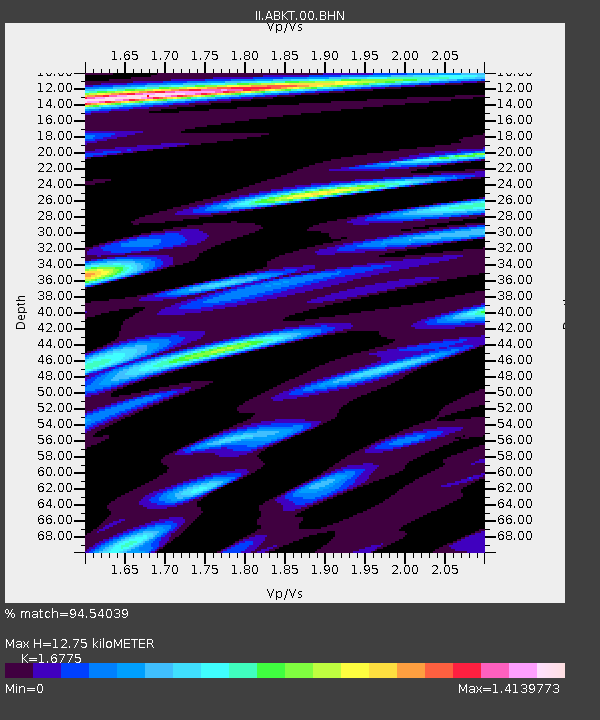
| Estimated Moho Depth: |
12.75 km |
| Estimated Crust Vp/Vs: |
1.68 |
| Assumed Crust Vp: |
6.53 km/s |
| Estimated Crust Vs: |
3.893 km/s |
| Estimated Crust Poisson's Ratio: |
0.22 |
|
| Radial Match: |
94.54039 % |
| Radial Bump: |
400 |
| Transverse Match: |
89.7078 % |
| Transverse Bump: |
400 |
| SOD ConfigId: |
2459 |
| Insert Time: |
2010-03-01 22:41:18.162 +0000 |
| GWidth: |
2.5 |
| Max Bumps: |
400 |
| Tol: |
0.001 |
|

Signal To Noise
| Channel | StoN | STA | LTA |
| II:ABKT:00:BHN:20041108T16:04:05.532019Z | 1.1909063 | 1.4424795E-7 | 1.211245E-7 |
| II:ABKT:00:BHE:20041108T16:04:05.532019Z | 2.1460574 | 3.0406173E-7 | 1.4168387E-7 |
| II:ABKT:00:BHZ:20041108T16:04:05.532019Z | 9.490785 | 9.254388E-7 | 9.75092E-8 |
| Arrivals |
| Ps | 1.4 SECOND |
| PpPs | 4.9 SECOND |
| PsPs/PpSs | 6.3 SECOND |


