You are here: Home > Network List > II - Global Seismograph Network (GSN - IRIS/IDA) Stations List
> Station ABKT Alibek, Turkmenistan > Earthquake Result Viewer
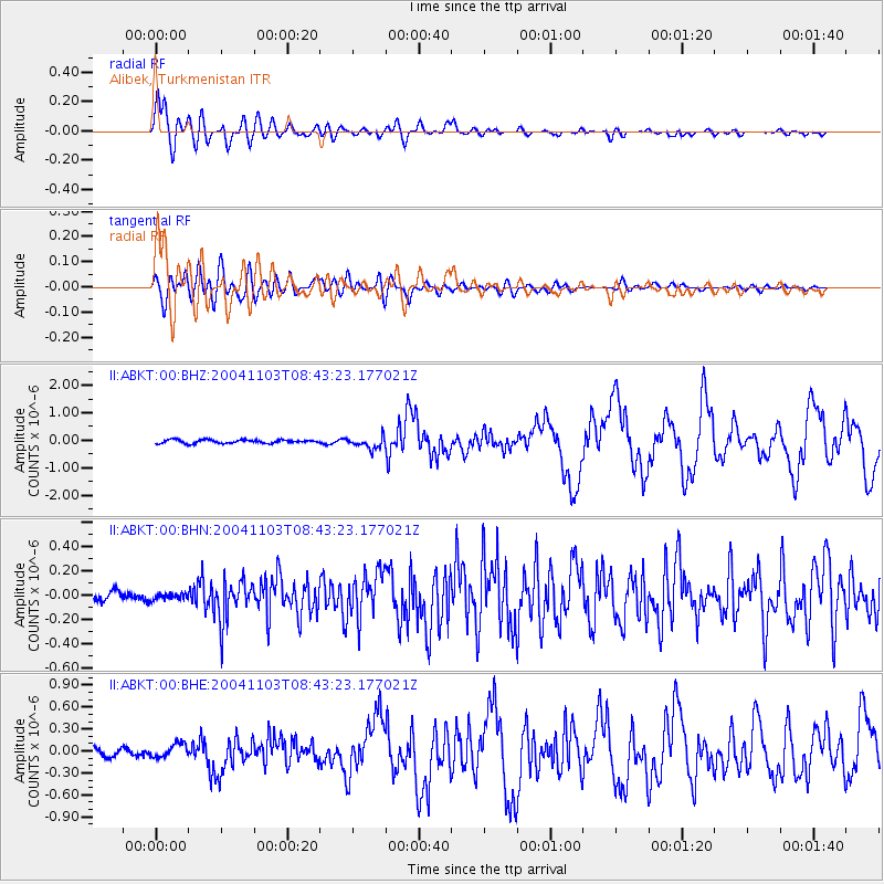
ABKT Alibek, Turkmenistan - Earthquake Result Viewer

| Earthquake location: |
Mariana Islands |
| Earthquake latitude/longitude: |
14.5/146.8 |
| Earthquake time(UTC): |
2004/11/03 (308) 08:31:43 GMT |
| Earthquake Depth: |
10 km |
| Earthquake Magnitude: |
5.6 MB, 5.8 MS, 6.0 MW, 5.9 MW |
| Earthquake Catalog/Contributor: |
WHDF/NEIC |
|
| Network: |
II Global Seismograph Network (GSN - IRIS/IDA) |
| Station: |
ABKT Alibek, Turkmenistan |
| Lat/Lon: |
37.93 N/58.12 E |
| Elevation: |
678 m |
|
| Distance: |
80.3 deg |
| Az: |
306.668 deg |
| Baz: |
79.289 deg |
| Ray Param: |
0.04839525 |
| Estimated Moho Depth: |
12.75 km |
| Estimated Crust Vp/Vs: |
1.62 |
| Assumed Crust Vp: |
6.53 km/s |
| Estimated Crust Vs: |
4.019 km/s |
| Estimated Crust Poisson's Ratio: |
0.20 |
|
| Radial Match: |
95.03841 % |
| Radial Bump: |
400 |
| Transverse Match: |
82.67632 % |
| Transverse Bump: |
400 |
| SOD ConfigId: |
2459 |
| Insert Time: |
2010-03-01 22:41:20.386 +0000 |
| GWidth: |
2.5 |
| Max Bumps: |
400 |
| Tol: |
0.001 |
|
Signal To Noise
| Channel | StoN | STA | LTA |
| II:ABKT:00:BHN:20041103T08:43:23.177021Z | 0.78712094 | 2.6131646E-8 | 3.3199022E-8 |
| II:ABKT:00:BHE:20041103T08:43:23.177021Z | 1.8953433 | 9.5918004E-8 | 5.060719E-8 |
| II:ABKT:00:BHZ:20041103T08:43:23.177021Z | 3.3508399 | 2.1671444E-7 | 6.4674666E-8 |
| Arrivals |
| Ps | 1.3 SECOND |
| PpPs | 5.0 SECOND |
| PsPs/PpSs | 6.2 SECOND |


