You are here: Home > Network List > TA - USArray Transportable Network (new EarthScope stations) Stations List
> Station W56A Indian Trail, NC, USA > Earthquake Result Viewer
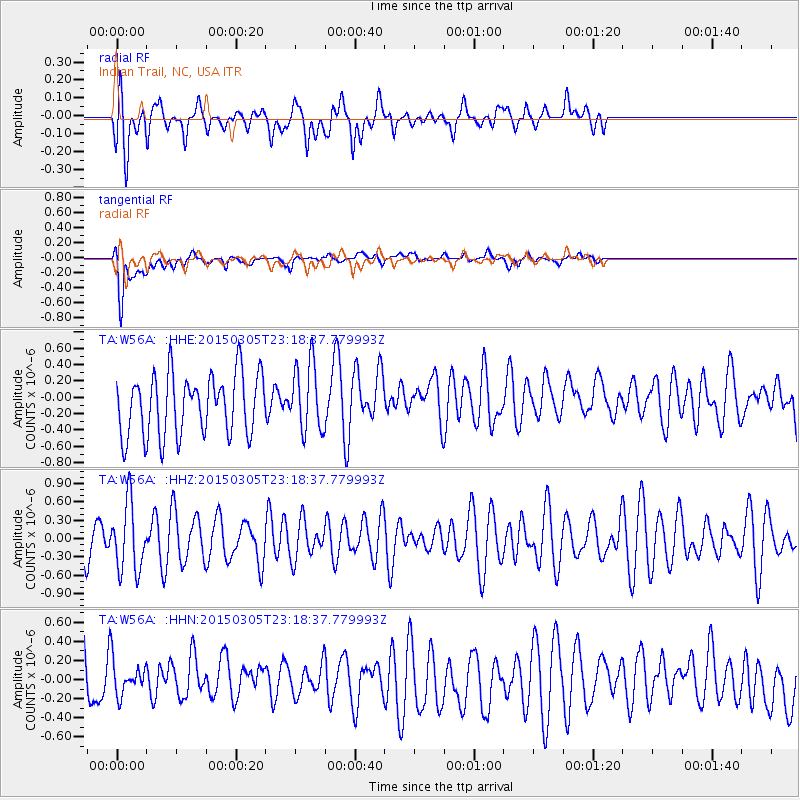
W56A Indian Trail, NC, USA - Earthquake Result Viewer
*The percent match for this event was below the threshold and hence no stack was calculated.
| Earthquake location: |
Hokkaido, Japan Region |
| Earthquake latitude/longitude: |
42.3/142.6 |
| Earthquake time(UTC): |
2015/03/05 (064) 23:06:00 GMT |
| Earthquake Depth: |
61 km |
| Earthquake Magnitude: |
4.8 MW |
| Earthquake Catalog/Contributor: |
ISC/ISC |
|
| Network: |
TA USArray Transportable Network (new EarthScope stations) |
| Station: |
W56A Indian Trail, NC, USA |
| Lat/Lon: |
35.13 N/80.58 W |
| Elevation: |
177 m |
|
| Distance: |
93.4 deg |
| Az: |
34.172 deg |
| Baz: |
329.461 deg |
| Ray Param: |
$rayparam |
*The percent match for this event was below the threshold and hence was not used in the summary stack. |
|
| Radial Match: |
60.088726 % |
| Radial Bump: |
400 |
| Transverse Match: |
70.973434 % |
| Transverse Bump: |
400 |
| SOD ConfigId: |
7019011 |
| Insert Time: |
2019-04-17 05:21:14.561 +0000 |
| GWidth: |
2.5 |
| Max Bumps: |
400 |
| Tol: |
0.001 |
|
Signal To Noise
| Channel | StoN | STA | LTA |
| TA:W56A: :HHZ:20150305T23:18:37.779993Z | 1.0644679 | 5.5153697E-7 | 5.1813396E-7 |
| TA:W56A: :HHN:20150305T23:18:37.779993Z | 0.69126713 | 1.835202E-7 | 2.6548378E-7 |
| TA:W56A: :HHE:20150305T23:18:37.779993Z | 1.1125671 | 4.1337245E-7 | 3.7154834E-7 |
| Arrivals |
| Ps | |
| PpPs | |
| PsPs/PpSs | |


