You are here: Home > Network List > II - Global Seismograph Network (GSN - IRIS/IDA) Stations List
> Station ABKT Alibek, Turkmenistan > Earthquake Result Viewer
ABKT Alibek, Turkmenistan - Earthquake Result Viewer
| Earthquake location: |
Taiwan Region |
| Earthquake latitude/longitude: |
24.5/122.7 |
| Earthquake time(UTC): |
2004/10/15 (289) 04:08:50 GMT |
| Earthquake Depth: |
94 km |
| Earthquake Magnitude: |
6.4 MB, 6.7 MW, 6.6 MW |
| Earthquake Catalog/Contributor: |
WHDF/NEIC |
|
| Network: |
II Global Seismograph Network (GSN - IRIS/IDA) |
| Station: |
ABKT Alibek, Turkmenistan |
| Lat/Lon: |
37.93 N/58.12 E |
| Elevation: |
678 m |
|
| Distance: |
55.8 deg |
| Az: |
300.302 deg |
| Baz: |
83.955 deg |
| Ray Param: |
0.0642726 |
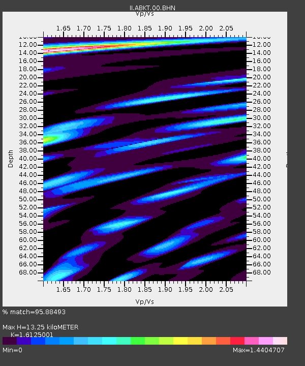
| Estimated Moho Depth: |
13.25 km |
| Estimated Crust Vp/Vs: |
1.61 |
| Assumed Crust Vp: |
6.53 km/s |
| Estimated Crust Vs: |
4.05 km/s |
| Estimated Crust Poisson's Ratio: |
0.19 |
|
| Radial Match: |
95.88493 % |
| Radial Bump: |
400 |
| Transverse Match: |
88.24829 % |
| Transverse Bump: |
400 |
| SOD ConfigId: |
2459 |
| Insert Time: |
2010-03-01 22:41:23.990 +0000 |
| GWidth: |
2.5 |
| Max Bumps: |
400 |
| Tol: |
0.001 |
|
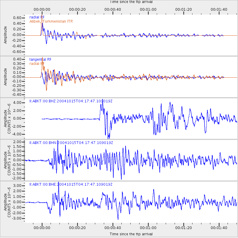
Signal To Noise
| Channel | StoN | STA | LTA |
| II:ABKT:00:BHN:20041015T04:17:47.109019Z | 4.371809 | 1.361138E-7 | 3.1134434E-8 |
| II:ABKT:00:BHE:20041015T04:17:47.109019Z | 18.491112 | 7.286218E-7 | 3.9403893E-8 |
| II:ABKT:00:BHZ:20041015T04:17:47.109019Z | 36.251114 | 1.7838313E-6 | 4.9207628E-8 |
| Arrivals |
| Ps | 1.3 SECOND |
| PpPs | 5.0 SECOND |
| PsPs/PpSs | 6.3 SECOND |


