You are here: Home > Network List > II - Global Seismograph Network (GSN - IRIS/IDA) Stations List
> Station ABKT Alibek, Turkmenistan > Earthquake Result Viewer
ABKT Alibek, Turkmenistan - Earthquake Result Viewer
| Earthquake location: |
Mindoro, Philippines |
| Earthquake latitude/longitude: |
13.9/120.5 |
| Earthquake time(UTC): |
2004/10/08 (282) 14:36:06 GMT |
| Earthquake Depth: |
105 km |
| Earthquake Magnitude: |
6.3 MB, 6.5 MW, 6.4 MW |
| Earthquake Catalog/Contributor: |
WHDF/NEIC |
|
| Network: |
II Global Seismograph Network (GSN - IRIS/IDA) |
| Station: |
ABKT Alibek, Turkmenistan |
| Lat/Lon: |
37.93 N/58.12 E |
| Elevation: |
678 m |
|
| Distance: |
59.9 deg |
| Az: |
305.871 deg |
| Baz: |
95.716 deg |
| Ray Param: |
0.061600517 |
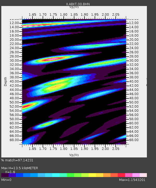
| Estimated Moho Depth: |
13.5 km |
| Estimated Crust Vp/Vs: |
1.60 |
| Assumed Crust Vp: |
6.53 km/s |
| Estimated Crust Vs: |
4.082 km/s |
| Estimated Crust Poisson's Ratio: |
0.18 |
|
| Radial Match: |
97.14231 % |
| Radial Bump: |
400 |
| Transverse Match: |
96.00742 % |
| Transverse Bump: |
400 |
| SOD ConfigId: |
2459 |
| Insert Time: |
2010-03-01 22:41:25.956 +0000 |
| GWidth: |
2.5 |
| Max Bumps: |
400 |
| Tol: |
0.001 |
|

Signal To Noise
| Channel | StoN | STA | LTA |
| II:ABKT:00:BHN:20041008T14:45:30.13002Z | 5.8964 | 1.8516677E-7 | 3.140336E-8 |
| II:ABKT:00:BHE:20041008T14:45:30.128005Z | 7.6516347 | 3.4477685E-7 | 4.505924E-8 |
| II:ABKT:00:BHZ:20041008T14:45:30.13002Z | 34.88919 | 1.5183115E-6 | 4.3518103E-8 |
| Arrivals |
| Ps | 1.3 SECOND |
| PpPs | 5.1 SECOND |
| PsPs/PpSs | 6.4 SECOND |


