You are here: Home > Network List > II - Global Seismograph Network (GSN - IRIS/IDA) Stations List
> Station ABKT Alibek, Turkmenistan > Earthquake Result Viewer
ABKT Alibek, Turkmenistan - Earthquake Result Viewer
| Earthquake location: |
Kamchatka Peninsula, Russia |
| Earthquake latitude/longitude: |
55.7/160.0 |
| Earthquake time(UTC): |
2004/06/10 (162) 15:19:57 GMT |
| Earthquake Depth: |
189 km |
| Earthquake Magnitude: |
6.1 MB, 6.9 MW, 6.9 MW |
| Earthquake Catalog/Contributor: |
WHDF/NEIC |
|
| Network: |
II Global Seismograph Network (GSN - IRIS/IDA) |
| Station: |
ABKT Alibek, Turkmenistan |
| Lat/Lon: |
37.93 N/58.12 E |
| Elevation: |
678 m |
|
| Distance: |
65.7 deg |
| Az: |
301.86 deg |
| Baz: |
37.469 deg |
| Ray Param: |
0.05757753 |
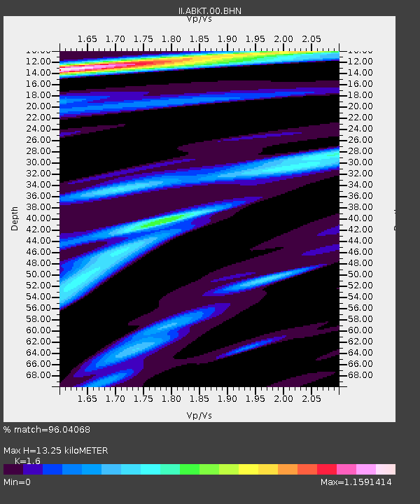
| Estimated Moho Depth: |
13.25 km |
| Estimated Crust Vp/Vs: |
1.60 |
| Assumed Crust Vp: |
6.53 km/s |
| Estimated Crust Vs: |
4.082 km/s |
| Estimated Crust Poisson's Ratio: |
0.18 |
|
| Radial Match: |
96.04068 % |
| Radial Bump: |
400 |
| Transverse Match: |
79.561775 % |
| Transverse Bump: |
400 |
| SOD ConfigId: |
2459 |
| Insert Time: |
2010-03-01 22:41:44.166 +0000 |
| GWidth: |
2.5 |
| Max Bumps: |
400 |
| Tol: |
0.001 |
|
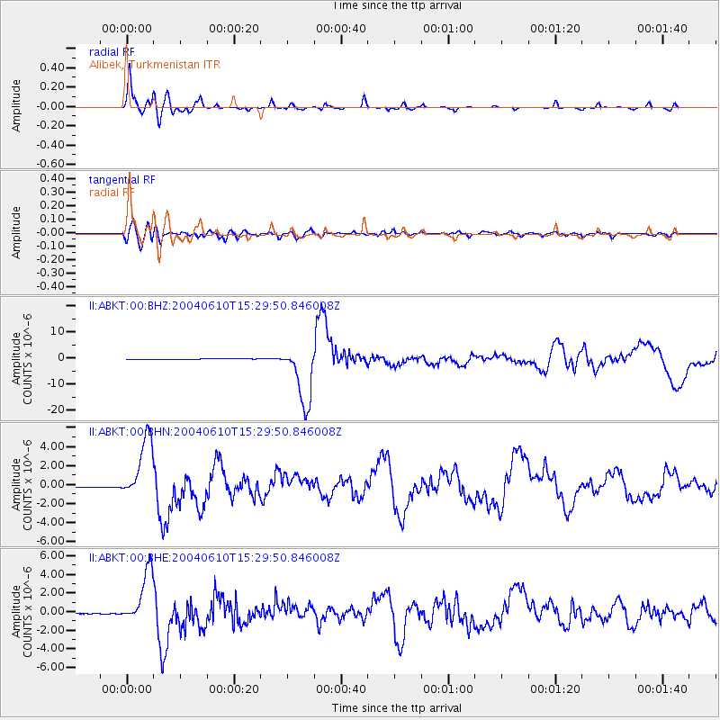
Signal To Noise
| Channel | StoN | STA | LTA |
| II:ABKT:00:BHN:20040610T15:29:50.846008Z | 68.51229 | 3.353823E-6 | 4.895214E-8 |
| II:ABKT:00:BHE:20040610T15:29:50.846008Z | 74.88914 | 2.9440728E-6 | 3.9312415E-8 |
| II:ABKT:00:BHZ:20040610T15:29:50.846008Z | 93.827934 | 1.173209E-5 | 1.2503835E-7 |
| Arrivals |
| Ps | 1.3 SECOND |
| PpPs | 5.0 SECOND |
| PsPs/PpSs | 6.3 SECOND |


