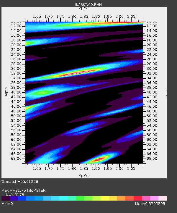
ABKT Alibek, Turkmenistan - Earthquake Result Viewer

Earthquake location: Off East Coast Of Honshu, Japan
Earthquake latitude/longitude: 34.3/141.4
Earthquake time(UTC): 2004/05/29 (150) 20:56:09 GMT
Earthquake Depth: 16 km
Earthquake Magnitude: 5.6 MB, 6.6 MS, 6.5 MW, 6.3 MW
Earthquake Catalog/Contributor: WHDF/NEIC
Network: II Global Seismograph Network (GSN - IRIS/IDA)
Station: ABKT Alibek, Turkmenistan
Lat/Lon: 37.93 N/58.12 E
Elevation: 678 m
Distance: 65.2 deg
Az: 300.101 deg
Baz: 64.993 deg
Ray Param: 0.058417626
Estimated Moho Depth: 31.75 km
Estimated Crust Vp/Vs: 1.82
Assumed Crust Vp: 6.53 km/s
Estimated Crust Vs: 3.593 km/s
Estimated Crust Poisson's Ratio: 0.28
Radial Match: 95.01226 %
Radial Bump: 400
Transverse Match: 83.72035 %
Transverse Bump: 400
SOD ConfigId: 2459
Insert Time: 2010-03-01 22:41:45.945 +0000
GWidth: 2.5
Max Bumps: 400
Tol: 0.001

Signal To Noise

ChannelStoNSTALTA
II:ABKT:00:BHN:20040529T21:06:18.839014Z4.98027371.7506962E-73.515261E-8
II:ABKT:00:BHE:20040529T21:06:18.839014Z16.9018273.835108E-72.2690495E-8
II:ABKT:00:BHZ:20040529T21:06:18.839014Z30.6734391.2197305E-63.976504E-8
Arrivals
Ps4.1 SECOND
PpPs13 SECOND
PsPs/PpSs17 SECOND