You are here: Home > Network List > CI - Caltech Regional Seismic Network Stations List
> Station VCS Vincent Substation, Palmdale, CA, USA > Earthquake Result Viewer
VCS Vincent Substation, Palmdale, CA, USA - Earthquake Result Viewer

| Earthquake location: |
Sea Of Japan |
| Earthquake latitude/longitude: |
36.8/134.9 |
| Earthquake time(UTC): |
2007/07/16 (197) 14:17:37 GMT |
| Earthquake Depth: |
350 km |
| Earthquake Magnitude: |
6.2 MB, 6.8 MW, 6.8 MW |
| Earthquake Catalog/Contributor: |
WHDF/NEIC |
|
| Network: |
CI Caltech Regional Seismic Network |
| Station: |
VCS Vincent Substation, Palmdale, CA, USA |
| Lat/Lon: |
34.48 N/118.12 W |
| Elevation: |
991 m |
|
| Distance: |
81.8 deg |
| Az: |
52.931 deg |
| Baz: |
309.174 deg |
| Ray Param: |
0.04637637 |
| Estimated Moho Depth: |
10.25 km |
| Estimated Crust Vp/Vs: |
1.60 |
| Assumed Crust Vp: |
6.1 km/s |
| Estimated Crust Vs: |
3.812 km/s |
| Estimated Crust Poisson's Ratio: |
0.18 |
|
| Radial Match: |
94.52668 % |
| Radial Bump: |
400 |
| Transverse Match: |
85.88255 % |
| Transverse Bump: |
400 |
| SOD ConfigId: |
2564 |
| Insert Time: |
2010-02-25 21:06:35.304 +0000 |
| GWidth: |
2.5 |
| Max Bumps: |
400 |
| Tol: |
0.001 |
|
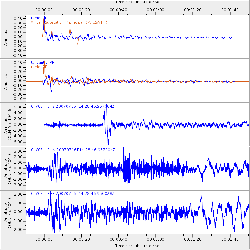
Signal To Noise
| Channel | StoN | STA | LTA |
| CI:VCS: :BHN:20070716T14:28:46.957004Z | 1.2399653 | 7.1195217E-7 | 5.7417105E-7 |
| CI:VCS: :BHE:20070716T14:28:46.956028Z | 1.8559189 | 8.3666043E-7 | 4.5080657E-7 |
| CI:VCS: :BHZ:20070716T14:28:46.957004Z | 11.316857 | 3.0767271E-6 | 2.7187116E-7 |
| Arrivals |
| Ps | 1.0 SECOND |
| PpPs | 4.3 SECOND |
| PsPs/PpSs | 5.3 SECOND |


