You are here: Home > Network List > IU - Global Seismograph Network (GSN - IRIS/USGS) Stations List
> Station SFJD Sondre Stromfjord, Greenland > Earthquake Result Viewer
SFJD Sondre Stromfjord, Greenland - Earthquake Result Viewer
| Earthquake location: |
Myanmar-China Border Region |
| Earthquake latitude/longitude: |
25.0/97.9 |
| Earthquake time(UTC): |
2014/05/30 (150) 01:20:15 GMT |
| Earthquake Depth: |
10 km |
| Earthquake Magnitude: |
5.9 MB |
| Earthquake Catalog/Contributor: |
NEIC PDE/NEIC COMCAT |
|
| Network: |
IU Global Seismograph Network (GSN - IRIS/USGS) |
| Station: |
SFJD Sondre Stromfjord, Greenland |
| Lat/Lon: |
67.00 N/50.62 W |
| Elevation: |
330 m |
|
| Distance: |
85.3 deg |
| Az: |
348.104 deg |
| Baz: |
28.424 deg |
| Ray Param: |
0.04486766 |
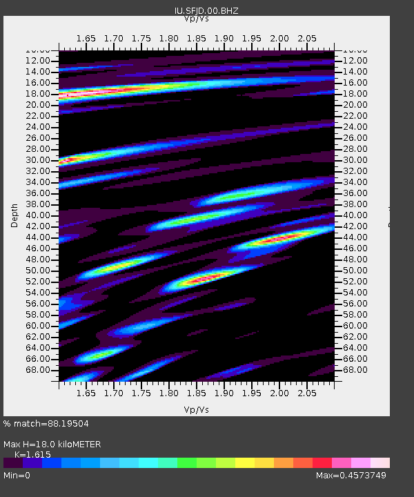
| Estimated Moho Depth: |
18.0 km |
| Estimated Crust Vp/Vs: |
1.62 |
| Assumed Crust Vp: |
6.459 km/s |
| Estimated Crust Vs: |
4.0 km/s |
| Estimated Crust Poisson's Ratio: |
0.19 |
|
| Radial Match: |
88.19504 % |
| Radial Bump: |
400 |
| Transverse Match: |
74.32726 % |
| Transverse Bump: |
400 |
| SOD ConfigId: |
626651 |
| Insert Time: |
2014-06-13 01:43:52.937 +0000 |
| GWidth: |
2.5 |
| Max Bumps: |
400 |
| Tol: |
0.001 |
|
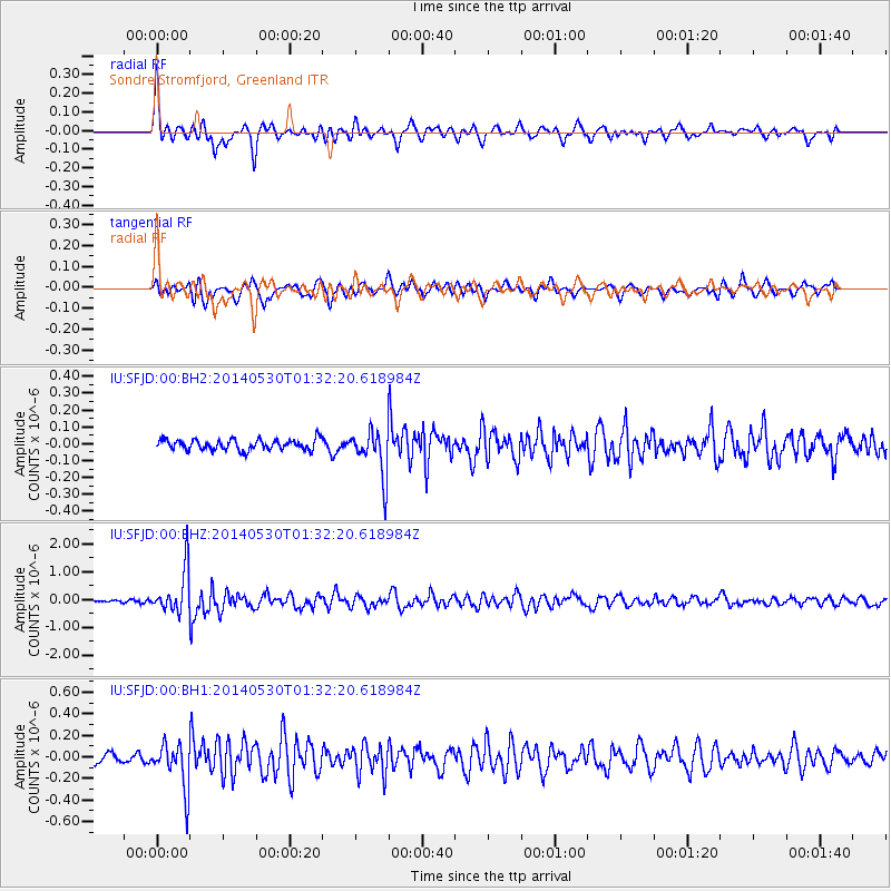
Signal To Noise
| Channel | StoN | STA | LTA |
| IU:SFJD:00:BHZ:20140530T01:32:20.618984Z | 17.526438 | 7.913387E-7 | 4.5151143E-8 |
| IU:SFJD:00:BH1:20140530T01:32:20.618984Z | 4.9602623 | 2.1053147E-7 | 4.2443613E-8 |
| IU:SFJD:00:BH2:20140530T01:32:20.618984Z | 4.2993536 | 1.3559205E-7 | 3.1537777E-8 |
| Arrivals |
| Ps | 1.8 SECOND |
| PpPs | 7.1 SECOND |
| PsPs/PpSs | 8.9 SECOND |


