You are here: Home > Network List > NI - North-East Italy Broadband Network Stations List
> Station CGRP Cima Grappa > Earthquake Result Viewer
CGRP Cima Grappa - Earthquake Result Viewer
| Earthquake location: |
Myanmar-China Border Region |
| Earthquake latitude/longitude: |
25.0/97.9 |
| Earthquake time(UTC): |
2014/05/30 (150) 01:20:15 GMT |
| Earthquake Depth: |
10 km |
| Earthquake Magnitude: |
5.9 MB |
| Earthquake Catalog/Contributor: |
NEIC PDE/NEIC COMCAT |
|
| Network: |
NI North-East Italy Broadband Network |
| Station: |
CGRP Cima Grappa |
| Lat/Lon: |
45.88 N/11.80 E |
| Elevation: |
1757 m |
|
| Distance: |
69.9 deg |
| Az: |
312.079 deg |
| Baz: |
74.64 deg |
| Ray Param: |
0.05535478 |
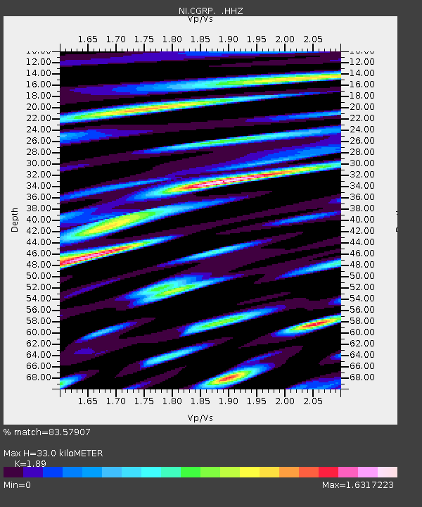
| Estimated Moho Depth: |
33.0 km |
| Estimated Crust Vp/Vs: |
1.89 |
| Assumed Crust Vp: |
6.155 km/s |
| Estimated Crust Vs: |
3.257 km/s |
| Estimated Crust Poisson's Ratio: |
0.31 |
|
| Radial Match: |
83.57907 % |
| Radial Bump: |
400 |
| Transverse Match: |
79.52231 % |
| Transverse Bump: |
400 |
| SOD ConfigId: |
626651 |
| Insert Time: |
2014-06-13 01:45:33.394 +0000 |
| GWidth: |
2.5 |
| Max Bumps: |
400 |
| Tol: |
0.001 |
|
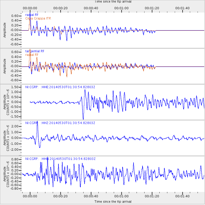
Signal To Noise
| Channel | StoN | STA | LTA |
| NI:CGRP: :HHZ:20140530T01:30:54.82803Z | 15.079159 | 7.6058626E-7 | 5.0439567E-8 |
| NI:CGRP: :HHN:20140530T01:30:54.82803Z | 2.3222752 | 9.886692E-8 | 4.25733E-8 |
| NI:CGRP: :HHE:20140530T01:30:54.82803Z | 5.867014 | 3.7506913E-7 | 6.3928454E-8 |
| Arrivals |
| Ps | 4.9 SECOND |
| PpPs | 15 SECOND |
| PsPs/PpSs | 20 SECOND |


