You are here: Home > Network List > NI - North-East Italy Broadband Network Stations List
> Station SABO Mt. Sabotino > Earthquake Result Viewer
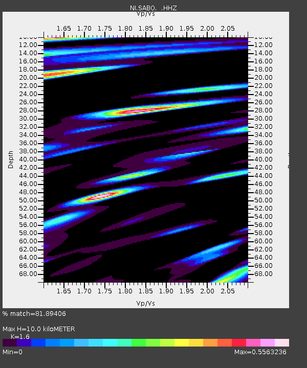
SABO Mt. Sabotino - Earthquake Result Viewer
| Earthquake location: |
Myanmar-China Border Region |
| Earthquake latitude/longitude: |
25.0/97.9 |
| Earthquake time(UTC): |
2014/05/30 (150) 01:20:15 GMT |
| Earthquake Depth: |
10 km |
| Earthquake Magnitude: |
5.9 MB |
| Earthquake Catalog/Contributor: |
NEIC PDE/NEIC COMCAT |
|
| Network: |
NI North-East Italy Broadband Network |
| Station: |
SABO Mt. Sabotino |
| Lat/Lon: |
45.99 N/13.63 E |
| Elevation: |
621 m |
|
| Distance: |
68.6 deg |
| Az: |
311.842 deg |
| Baz: |
75.866 deg |
| Ray Param: |
0.056187507 |
| Estimated Moho Depth: |
10.0 km |
| Estimated Crust Vp/Vs: |
1.60 |
| Assumed Crust Vp: |
6.207 km/s |
| Estimated Crust Vs: |
3.879 km/s |
| Estimated Crust Poisson's Ratio: |
0.18 |
|
| Radial Match: |
81.89406 % |
| Radial Bump: |
400 |
| Transverse Match: |
87.12249 % |
| Transverse Bump: |
400 |
| SOD ConfigId: |
626651 |
| Insert Time: |
2014-06-13 01:45:57.366 +0000 |
| GWidth: |
2.5 |
| Max Bumps: |
400 |
| Tol: |
0.001 |
|

Signal To Noise
| Channel | StoN | STA | LTA |
| NI:SABO: :HHZ:20140530T01:30:47.037991Z | 19.848757 | 1.29556E-6 | 6.527159E-8 |
| NI:SABO: :HHN:20140530T01:30:47.037991Z | 1.6132454 | 8.2300446E-8 | 5.1015455E-8 |
| NI:SABO: :HHE:20140530T01:30:47.037991Z | 6.609929 | 3.2890904E-7 | 4.9759844E-8 |
| Arrivals |
| Ps | 1.0 SECOND |
| PpPs | 4.0 SECOND |
| PsPs/PpSs | 5.0 SECOND |


