You are here: Home > Network List > II - Global Seismograph Network (GSN - IRIS/IDA) Stations List
> Station ABKT Alibek, Turkmenistan > Earthquake Result Viewer
ABKT Alibek, Turkmenistan - Earthquake Result Viewer
| Earthquake location: |
Southern Sumatra, Indonesia |
| Earthquake latitude/longitude: |
-2.4/104.0 |
| Earthquake time(UTC): |
2004/07/25 (207) 14:35:19 GMT |
| Earthquake Depth: |
582 km |
| Earthquake Magnitude: |
6.8 MB, 7.3 MW, 7.3 MW |
| Earthquake Catalog/Contributor: |
WHDF/NEIC |
|
| Network: |
II Global Seismograph Network (GSN - IRIS/IDA) |
| Station: |
ABKT Alibek, Turkmenistan |
| Lat/Lon: |
37.93 N/58.12 E |
| Elevation: |
678 m |
|
| Distance: |
58.4 deg |
| Az: |
318.202 deg |
| Baz: |
122.634 deg |
| Ray Param: |
0.06050522 |
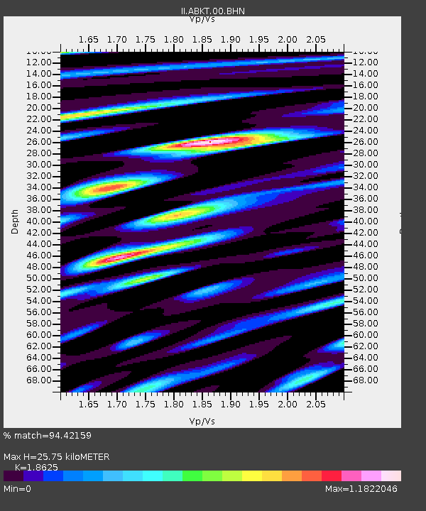
| Estimated Moho Depth: |
25.75 km |
| Estimated Crust Vp/Vs: |
1.86 |
| Assumed Crust Vp: |
6.53 km/s |
| Estimated Crust Vs: |
3.506 km/s |
| Estimated Crust Poisson's Ratio: |
0.30 |
|
| Radial Match: |
94.42159 % |
| Radial Bump: |
400 |
| Transverse Match: |
91.43961 % |
| Transverse Bump: |
400 |
| SOD ConfigId: |
2459 |
| Insert Time: |
2010-03-01 22:42:18.236 +0000 |
| GWidth: |
2.5 |
| Max Bumps: |
400 |
| Tol: |
0.001 |
|

Signal To Noise
| Channel | StoN | STA | LTA |
| II:ABKT:00:BHN:20040725T14:43:48.700015Z | 77.050835 | 4.7964018E-6 | 6.224984E-8 |
| II:ABKT:00:BHE:20040725T14:43:48.700015Z | 47.33932 | 5.0388053E-6 | 1.0644016E-7 |
| II:ABKT:00:BHZ:20040725T14:43:48.700015Z | 57.375237 | 1.3879121E-5 | 2.419009E-7 |
| Arrivals |
| Ps | 3.6 SECOND |
| PpPs | 11 SECOND |
| PsPs/PpSs | 14 SECOND |


