You are here: Home > Network List > UW - Pacific Northwest Regional Seismic Network Stations List
> Station PASS Maple Falls, WA, USA > Earthquake Result Viewer
PASS Maple Falls, WA, USA - Earthquake Result Viewer
| Earthquake location: |
Northern Chile |
| Earthquake latitude/longitude: |
-21.3/-70.0 |
| Earthquake time(UTC): |
2014/05/30 (150) 15:32:27 GMT |
| Earthquake Depth: |
57 km |
| Earthquake Magnitude: |
5.6 MWW, 5.5 MWR, 5.6 MWB |
| Earthquake Catalog/Contributor: |
NEIC PDE/NEIC COMCAT |
|
| Network: |
UW Pacific Northwest Regional Seismic Network |
| Station: |
PASS Maple Falls, WA, USA |
| Lat/Lon: |
49.00 N/122.09 W |
| Elevation: |
174 m |
|
| Distance: |
84.0 deg |
| Az: |
328.479 deg |
| Baz: |
132.246 deg |
| Ray Param: |
0.045714576 |
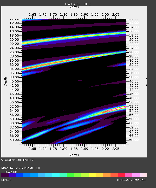
| Estimated Moho Depth: |
52.75 km |
| Estimated Crust Vp/Vs: |
2.06 |
| Assumed Crust Vp: |
6.566 km/s |
| Estimated Crust Vs: |
3.187 km/s |
| Estimated Crust Poisson's Ratio: |
0.35 |
|
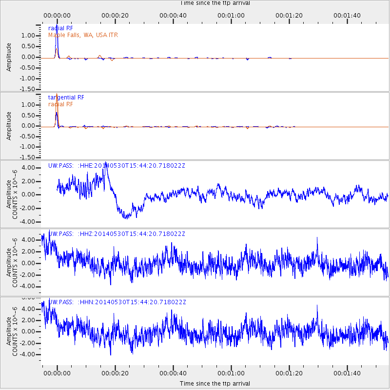
| Radial Match: |
98.89817 % |
| Radial Bump: |
64 |
| Transverse Match: |
96.44292 % |
| Transverse Bump: |
233 |
| SOD ConfigId: |
626651 |
| Insert Time: |
2014-06-13 16:25:16.189 +0000 |
| GWidth: |
2.5 |
| Max Bumps: |
400 |
| Tol: |
0.001 |
|
Signal To Noise
| Channel | StoN | STA | LTA |
| UW:PASS: :HHZ:20140530T15:44:20.718022Z | 0.8279053 | 3.0659367E-6 | 3.7032455E-6 |
| UW:PASS: :HHN:20140530T15:44:20.718022Z | 0.81477904 | 3.2905427E-6 | 4.0385708E-6 |
| UW:PASS: :HHE:20140530T15:44:20.718022Z | 0.83024234 | 1.5527689E-6 | 1.8702598E-6 |
| Arrivals |
| Ps | 8.7 SECOND |
| PpPs | 24 SECOND |
| PsPs/PpSs | 33 SECOND |


