You are here: Home > Network List > II - Global Seismograph Network (GSN - IRIS/IDA) Stations List
> Station ABKT Alibek, Turkmenistan > Earthquake Result Viewer
ABKT Alibek, Turkmenistan - Earthquake Result Viewer
| Earthquake location: |
Northeast Of Taiwan |
| Earthquake latitude/longitude: |
25.3/123.4 |
| Earthquake time(UTC): |
2005/10/15 (288) 15:51:07 GMT |
| Earthquake Depth: |
183 km |
| Earthquake Magnitude: |
6.2 MB, 6.5 MW, 6.5 MW |
| Earthquake Catalog/Contributor: |
WHDF/NEIC |
|
| Network: |
II Global Seismograph Network (GSN - IRIS/IDA) |
| Station: |
ABKT Alibek, Turkmenistan |
| Lat/Lon: |
37.93 N/58.12 E |
| Elevation: |
678 m |
|
| Distance: |
55.9 deg |
| Az: |
299.913 deg |
| Baz: |
82.767 deg |
| Ray Param: |
0.0638576 |
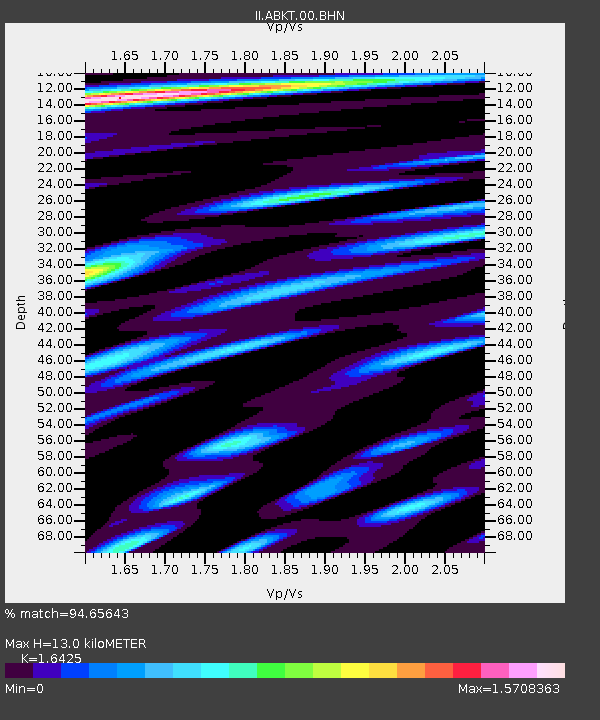
| Estimated Moho Depth: |
13.0 km |
| Estimated Crust Vp/Vs: |
1.64 |
| Assumed Crust Vp: |
6.53 km/s |
| Estimated Crust Vs: |
3.976 km/s |
| Estimated Crust Poisson's Ratio: |
0.21 |
|
| Radial Match: |
94.65643 % |
| Radial Bump: |
400 |
| Transverse Match: |
91.310196 % |
| Transverse Bump: |
400 |
| SOD ConfigId: |
2564 |
| Insert Time: |
2010-03-01 22:42:57.105 +0000 |
| GWidth: |
2.5 |
| Max Bumps: |
400 |
| Tol: |
0.001 |
|
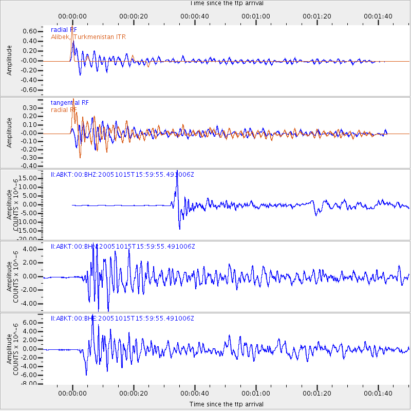
Signal To Noise
| Channel | StoN | STA | LTA |
| II:ABKT:00:BHN:20051015T15:59:55.491006Z | 5.3382854 | 2.562975E-7 | 4.8011206E-8 |
| II:ABKT:00:BHE:20051015T15:59:55.491006Z | 24.240646 | 1.7429495E-6 | 7.1901944E-8 |
| II:ABKT:00:BHZ:20051015T15:59:55.491006Z | 69.27725 | 5.787761E-6 | 8.35449E-8 |
| Arrivals |
| Ps | 1.4 SECOND |
| PpPs | 5.0 SECOND |
| PsPs/PpSs | 6.3 SECOND |


