You are here: Home > Network List > LD - Lamont-Doherty Cooperative Seismographic Network Stations List
> Station BRNY Black Rock Forest, Cornwall, NY > Earthquake Result Viewer
BRNY Black Rock Forest, Cornwall, NY - Earthquake Result Viewer
| Earthquake location: |
Off Coast Of Jalisco, Mexico |
| Earthquake latitude/longitude: |
18.9/-107.4 |
| Earthquake time(UTC): |
2014/05/31 (151) 11:53:48 GMT |
| Earthquake Depth: |
10 km |
| Earthquake Magnitude: |
6.2 MWP, 6.6 MI |
| Earthquake Catalog/Contributor: |
NEIC PDE/NEIC COMCAT |
|
| Network: |
LD Lamont-Doherty Cooperative Seismographic Network |
| Station: |
BRNY Black Rock Forest, Cornwall, NY |
| Lat/Lon: |
41.41 N/74.01 W |
| Elevation: |
248 m |
|
| Distance: |
36.3 deg |
| Az: |
44.447 deg |
| Baz: |
241.845 deg |
| Ray Param: |
0.07676441 |
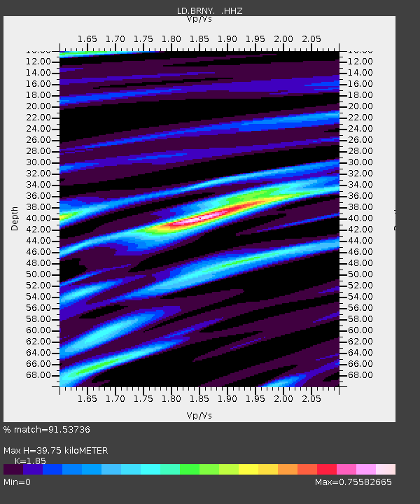
| Estimated Moho Depth: |
39.75 km |
| Estimated Crust Vp/Vs: |
1.85 |
| Assumed Crust Vp: |
6.283 km/s |
| Estimated Crust Vs: |
3.396 km/s |
| Estimated Crust Poisson's Ratio: |
0.29 |
|
| Radial Match: |
91.53736 % |
| Radial Bump: |
156 |
| Transverse Match: |
74.50094 % |
| Transverse Bump: |
367 |
| SOD ConfigId: |
626651 |
| Insert Time: |
2014-06-14 12:21:34.864 +0000 |
| GWidth: |
2.5 |
| Max Bumps: |
400 |
| Tol: |
0.001 |
|

Signal To Noise
| Channel | StoN | STA | LTA |
| LD:BRNY: :HHZ:20140531T12:00:20.790002Z | 6.6908236 | 5.2411343E-7 | 7.8333166E-8 |
| LD:BRNY: :HHN:20140531T12:00:20.790002Z | 2.0031528 | 1.677044E-7 | 8.3720224E-8 |
| LD:BRNY: :HHE:20140531T12:00:20.790002Z | 6.249273 | 3.6527518E-7 | 5.8450834E-8 |
| Arrivals |
| Ps | 5.8 SECOND |
| PpPs | 17 SECOND |
| PsPs/PpSs | 23 SECOND |


