You are here: Home > Network List > TA - USArray Transportable Network (new EarthScope stations) Stations List
> Station C06D Leavenworth, WQ, USA > Earthquake Result Viewer
C06D Leavenworth, WQ, USA - Earthquake Result Viewer
| Earthquake location: |
Off Coast Of Jalisco, Mexico |
| Earthquake latitude/longitude: |
18.9/-107.4 |
| Earthquake time(UTC): |
2014/05/31 (151) 11:53:48 GMT |
| Earthquake Depth: |
10 km |
| Earthquake Magnitude: |
6.2 MWP, 6.6 MI |
| Earthquake Catalog/Contributor: |
NEIC PDE/NEIC COMCAT |
|
| Network: |
TA USArray Transportable Network (new EarthScope stations) |
| Station: |
C06D Leavenworth, WQ, USA |
| Lat/Lon: |
47.92 N/120.89 W |
| Elevation: |
544 m |
|
| Distance: |
31.0 deg |
| Az: |
342.317 deg |
| Baz: |
154.679 deg |
| Ray Param: |
0.07918466 |
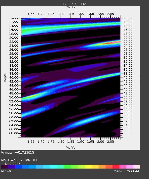
| Estimated Moho Depth: |
21.75 km |
| Estimated Crust Vp/Vs: |
2.10 |
| Assumed Crust Vp: |
6.597 km/s |
| Estimated Crust Vs: |
3.145 km/s |
| Estimated Crust Poisson's Ratio: |
0.35 |
|
| Radial Match: |
91.723015 % |
| Radial Bump: |
334 |
| Transverse Match: |
75.6441 % |
| Transverse Bump: |
400 |
| SOD ConfigId: |
626651 |
| Insert Time: |
2014-06-14 12:28:24.949 +0000 |
| GWidth: |
2.5 |
| Max Bumps: |
400 |
| Tol: |
0.001 |
|
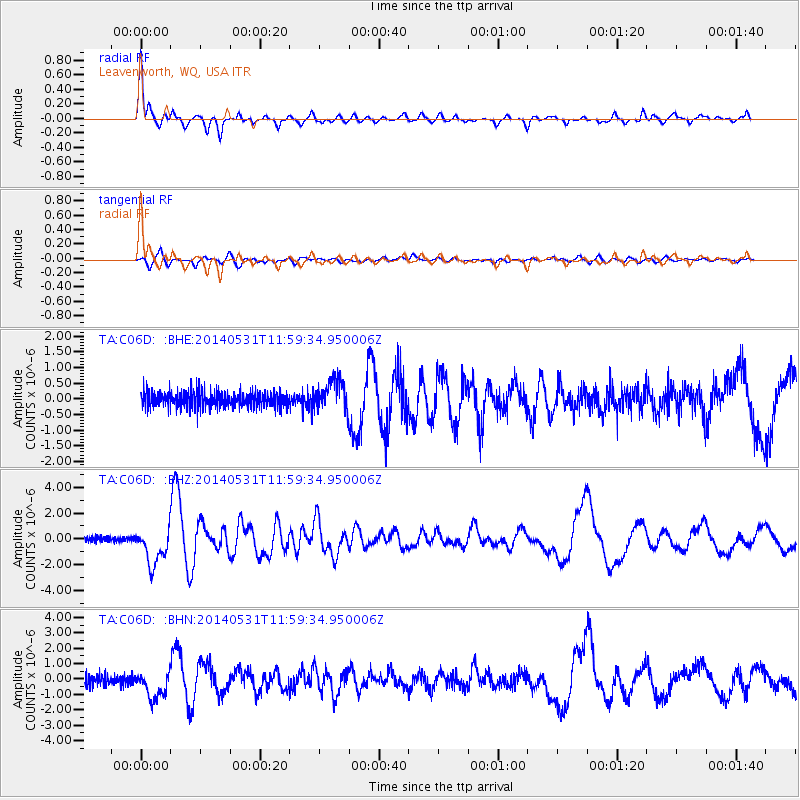
Signal To Noise
| Channel | StoN | STA | LTA |
| TA:C06D: :BHZ:20140531T11:59:34.950006Z | 9.742934 | 1.4098321E-6 | 1.4470304E-7 |
| TA:C06D: :BHN:20140531T11:59:34.950006Z | 2.7965033 | 8.5152533E-7 | 3.0449647E-7 |
| TA:C06D: :BHE:20140531T11:59:34.950006Z | 1.9571732 | 4.94246E-7 | 2.5253053E-7 |
| Arrivals |
| Ps | 3.9 SECOND |
| PpPs | 9.5 SECOND |
| PsPs/PpSs | 13 SECOND |


